San Antonio de Areco
San Antonio de Areco | |
|---|---|
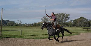
 A modern-day gaucho takes a stab at Carrera de sortija (ring-spearing contest) at Estancia La Cinacina | |
| Country | |
| Province | |
| Partido | San Antonio de Areco |
| Founded | October 23, 1730 |
| Elevation | 26 m (85 ft) |
| Population | |
• Total | 17,764 |
| CPA Base | B 2760 |
| Area code | +54 2326 |
San Antonio de Areco is a town in northern Buenos Aires Province, Argentina, and administrative seat of the partido of San Antonio de Areco. It is located on the Areco River 113 km (70 mi) away from the Buenos Aires city, the country's capital.
San Antonio de Areco was founded in 1730, under the protection of a chapel inaugurated by José Ruiz de Arellano. It has been declared city of historic national interest by the Argentine Government and is recognized for being the homeland of Don Segundo Sombra, the immortal character of the novel written by Ricardo Güiraldes. The city is the home of the Museo Gauchesco Ricardo Güiraldes. Each year in November, the city holds the Día de la Tradición (Tradition Day) gaucho celebration. Since 2001, San Antonio de Areco is sister city of Laredo, Texas in the United States.
Geographical features
Population: the city has 23 114 inhabitants (INDEC, 2010), against 17 764 inhabitants registered in the previous census (INDEC, 2001).
San Antonio de Areco is located in the north east region of Buenos Aires province.
External links


- Municipal information: Municipal Affairs Federal Institute (IFAM), Municipal Affairs Secretariat, Ministry of Interior, Argentina. (in Spanish)
- Tradition Festival- Event Schedule
- Turismo en San Antonio de Areco - Tourism
- Areco Ciudad - News
- Secretary of Tourism
- Don Segundo Sombra
34°15′S 59°28′W / 34.250°S 59.467°W
