
San Lorenzo Tenochtitlán

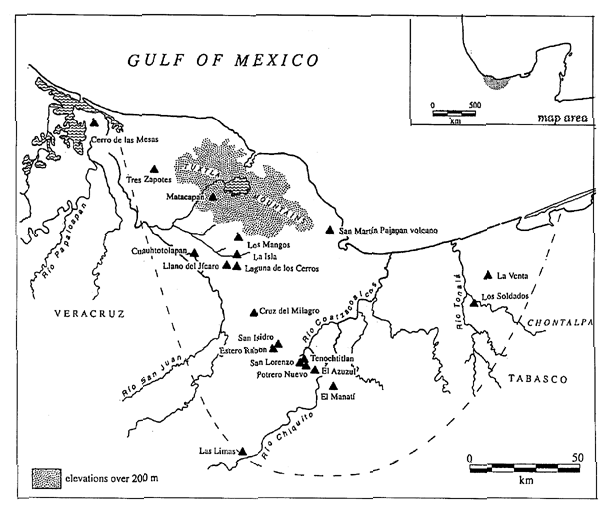
San Lorenzo Tenochtitlán (or San Lorenzo) is the collective name for three related archaeological sites -- San Lorenzo, Tenochtitlán, and Potrero Nuevo -- located in the southeast portion of the Mexican state of Veracruz. From 1200 BCE to 900 BCE, it was the major center of Olmec culture. San Lorenzo Tenochtitlán is best known today for the colossal stone heads unearthed there, the greatest of which weigh 20 tons or more and are 3 meters high.
The site should not be confused with Tenochtitlan, the Aztec site in Mexico City.
Description
The earliest evidence for Olmec culture is found at nearby El Manati, a sacrificial bog with artifacts dating to 1600 BCE or earlier. Sedentary agriculturalists had lived in the area for centuries before San Lorenzo developed into a regional center.[1]
San Lorenzo was the largest city in Mesoamerica from roughly 1200 BCE to 900 BCE, at which time it had begun to be overtaken by the Olmec center of La Venta. By 800 BCE, there was little or no population, although there was an important recolonization of the San Lorenzo plateau from 600 to 400 BCE and again from circa 800 to 1000 CE.
In contrast to La Venta's swamp-like environs, San Lorenzo was situated in the midst of a large agricultural area.[2] San Lorenzo seems to have been largely a ceremonial site, a town without city walls, centered in the midst of a widespread medium-to-large agricultural population. The ceremonial center and attendant buildings could have housed 5,500 while the entire area, including hinterlands, could have reached 13,000.[3]
It is thought that while San Lorenzo controlled much or all of the Coatzacoalcos basin, areas to the east (such as the area where La Venta would rise to prominence) and north-northwest (such as the Tuxtla Mountains) were home to independent polities.[4]
Built on some 700 hectares of high ground between then-active tributaries, the core of San Lorenzo covers 55 hectares[5] that were further modified through extensive filling and leveling; by one estimate half-a-million to 2 million cubic meters of earthen fill were needed, moved by the basketload.
San Lorenzo also boasted an elaborate drainage system which used buried, covered, channeled stones as a type of "pipe". Some researchers have inferred that the purpose of this system was not only to provide drinking water for the population but for ritual purposes as well, and that the rulership was "intimately linked to the figure of a patron water supernatural".[6]

Archaeological history
Matthew Stirling was the first to begin excavations on the site after a visit in 1938.[7] Between 1946 and 1970, four archaeological projects were undertaken, with a lull until 1990. The archaeology work recommenced in 1990, putting emphasis on the establishment pattern of community and regional levels ("en el patrón de asentamiento en los niveles de comunidad y de región".[8].
The original Olmec name of the area, like nearly all of the Olmec language, is unknown. The name "San Lorenzo Tenochtitlán" was coined by Stirling in 1955, taken from the nearby present-day villages, and refers to the entire complex of sites.
The archaeological sites of San Lorenzo Tenochtitlán can be visited Monday to Sunday, from 8:00 to 15:00 hours local time.
Notes
References
- Beck, Roger B. (1999). World History: Patterns of Interaction. Evanston, IL: McDougal Littell. ISBN 0-395-87274-X.
{{cite book}}: Unknown parameter|coauthors=ignored (|author=suggested) (help); templatestyles stripmarker in|author=at position 1 (help); templatestyles stripmarker in|coauthors=at position 1 (help)CS1 maint: numeric names: authors list (link) - Clark, John E. (2000) "Gulf Lowlands: South Region", in Archaeology of Ancient Mexico and Central America: an Encyclopedia, ed. Evans, Susan; Routledge.
- Coe, Michael D. (1967) "San Lorenzo and the Olmec Civilization", in Dumbarton Oaks Conference on the Olmec, Dumbarton Oaks, Washington, D.C.
- Cyphers, Ann (1999) "From Stone to Symbols: Olmec Art in Social Context at San Lorenzo Tenochtitlán", in Social Patterns in Pre-Classic Mesoamerica, Dumbarton Oaks, Washington, D.C., pp. 155 - 181.
- Lawler, Andrew (2007) "Beyond the Family Feud", in Archaeology; Mar/Apr 2007, Vol. 60 Issue 2, pp. 20-25.
- The National Institute of Anthropology and History (INAH) San Lorenzo website
- Pool, Christopher A. (2007). Olmec Archaeology and Early Mesoamerica. Cambridge: Cambridge University Press. ISBN 978-0-521-78882-3.
{{cite book}}: templatestyles stripmarker in|author=at position 1 (help)CS1 maint: numeric names: authors list (link)
See also
- El Azuzul, a small Olmec site just southeast of San Lorenzo Tenochtitlán and perhaps part of the complex.
- Tres Zapotes, a major Olmec and post-Olmec site roughly 100 miles (160 km) northwest of the San Lorenzo complex.