
Sancti Spíritus
Sancti Spíritus | |
|---|---|
 Yayabo Bridge over the Yayabo River | |
.png) Sancti Spíritus municipality (red) within Sancti Spíritus Province (yellow) and Cuba | |
| Country | |
| Province | Sancti Spíritus |
| Founded | 1514[1] |
| Area | |
| • Total | 1,150.7 km2 (444.3 sq mi) |
| Elevation | 51 m (167 ft) |
| Population (2004)[3] | |
| • Total | 133,843 |
| • Density | 116.3/km2 (301/sq mi) |
| Demonym | Espirituana/o |
| Time zone | UTC-5 (EST) |
| Postal code | 60100 |
| Area code | +53 41 |

Sancti Spíritus is a municipality and capital city of the province of Sancti Spíritus in central Cuba. Sancti Spíritus, Latin for "Holy Spirit". is one of the oldest Cuban European settlements.
History
The city was founded by Diego Velázquez de Cuéllar in 1514.[1] Francisco Iznaga, a rich Basque landowner in the western portion of Cuba during the first thirty years of the colonization of Cuba, was elected mayor of Bayamo in 1540. Iznaga was the originator of a powerful lineage that finally settled in Sancti Spiritus and Trinidad where Torre Iznaga is. Iznaga's descendants fought for the Independence of Cuba and the Annexation to the US from 1820 to 1900.
The Parroquial Mayor is located two blocks south of the town's main square; it is a venerable green-towered church whose early 16th-century origins make it the country's oldest. Nearby is the Museo de Arte Colonial (Colonial Art Museum), one of Sancti Spíritus's most splendid colonial homes and a standout attraction. The opulent former palatial mansion of the Valle Iznaga clan, one of Cuba's most elite families who fled Cuba after Fidel's Revolution, it became the property of the state in 1961. Ninety percent of what you see inside, from furniture to paintings, is original. Though the family obviously kept an impressive collection of Limoges porcelain, French gilded mirrors, Italian marble tables, and Baccarat crystal chandeliers here, it wasn't their primary residence; the house was used mostly to host family members in transit, so the furnishings were rather eclectic. The three bedrooms are decorated in grand style, though, with handmade lace, embroidered sheets, and hand-painted glass. There is a gorgeous and very Cuban leather sillón fumador (smoking chair) and, in the music room, the mid-18th-century American piano, one of only two of its type in Cuba. In the tearoom is the family seal, which says: "El que más vale no vale tanto como Valle vale" ("He who has the greatest worth isn't worth as much as a Valle is worth"—playing off the Spanish word for "worth" with the family surname).
Another interesting landmark is one of Cuba's older bridges over the Yayabo river. Built in 1815 with clay bricks it forms five arcs, the center being 9 meters tall. The entire bridge is only 85 meters long and was designed for pedestrians and carriages during colonial-era Cuba but has thus far resisted heavier modern traffic.
Sancti Spíritus has a worldwide famous Medical University located at the Main road in Olivos III. It has students from all over the world representing 34 nationalities. It is also the home of the Sancti Spíritus Gallos baseball team.
Geography
The municipality is divided into the barrios of Banao, Bellamota, Bijabo, Guasimal, Hospital, Jíbaro, Manacas, Mapos, Paredes, Paula, Pelayo, Pueblo Nuevo, San Andrés, Tuinicú, Tunas de Zaza and Zaza del Medio.[1]
The Zaza Reservoir is located southwest of the city.
The city has a central park which is a place of great entertainment for the persons of all ages.
Climate
According to the Köppen Climate Classification system, Sancti Spíritus has a tropical savanna climate, abbreviated "Aw" on climate maps.[4]
| Climate data for Sancti Spíritus | |||||||||||||
|---|---|---|---|---|---|---|---|---|---|---|---|---|---|
| Month | Jan | Feb | Mar | Apr | May | Jun | Jul | Aug | Sep | Oct | Nov | Dec | Year |
| Mean daily maximum °C (°F) | 27 (80) |
27 (80) |
28 (83) |
29 (84) |
30 (86) |
30 (86) |
31 (87) |
31 (88) |
30 (86) |
29 (85) |
28 (82) |
27 (80) |
29 (84) |
| Mean daily minimum °C (°F) | 18 (64) |
18 (64) |
19 (67) |
20 (68) |
22 (72) |
23 (74) |
23 (74) |
23 (74) |
23 (73) |
22 (72) |
21 (69) |
19 (66) |
21 (70) |
| Average precipitation mm (inches) | 30 (1.2) |
43 (1.7) |
46 (1.8) |
69 (2.7) |
210 (8.3) |
280 (11) |
200 (7.7) |
200 (8) |
200 (7.8) |
220 (8.7) |
51 (2) |
23 (0.9) |
1,572 (61.8) |
| Source: Weatherbase [5] | |||||||||||||
Demographics
In 2004, the municipality of Sancti Spíritus had a population of 133,843.[3] With a total area of 1,151 km2 (444 sq mi),[2] this means a population density of 116.3/km2 (301/sq mi).
Gallery
-
 Street shop
 -
 Street shop
 -
 Street scene
 -
 Street scene
 -
 Museo de Arte Colonial
 -
 Horse with cart
 -
 Street scene
 -
 Doorway
 -
 Street shop (from sleeping room)
 -
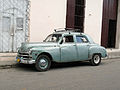 A "Yank tank"
 -
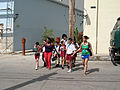
 Pedestrian zone
 -
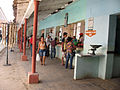
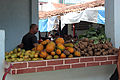
 Agricultural Market
 -
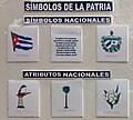 "Symbols of the Fatherland"
 -
 Agricultural Market
 -
 Agricultural Market
 -
 The Parroquial Mayor, Cuba's oldest church, in Sancti Spiritus center
 -
 Parroquial Mayor
 -
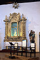 Side Altar, Parroquial Mayor
 -
 "The Last Supper", Parroquial Mayor


_in_Sancti_Spiritus.jpg)


See also
References
- ^ a b c Guije.com. "Sancti Spíritus". Retrieved 2007-10-07. Template:Es icon
- ^ a b Statoids (July 2003). "Municipios of Cuba". Retrieved 2007-10-07.
- ^ a b Atenas.cu (2004). "2004 Population trends, by Province and Municipality". Archived from the original on 2007-09-27. Retrieved 2007-10-07. Template:Es icon
- ^ Climate Summary for Sancti Spiritus, Cuba
- ^ "Weatherbase.com". Weatherbase. 2013. Retrieved on October 13, 2013.