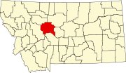
Sand Coulee, Montana
Appearance
Sand Coulee, Montana | |
|---|---|
| Coordinates: 47°23′58″N 111°10′04″W / 47.39944°N 111.16778°W | |
| Country | United States |
| State | Montana |
| County | Cascade |
| Area | |
| • Total | 2.621 sq mi (6.79 km2) |
| • Land | 2.621 sq mi (6.79 km2) |
| • Water | 0 sq mi (0 km2) |
| Elevation | 3,471 ft (1,058 m) |
| Population | |
| • Total | 212 |
| • Density | 81/sq mi (31/km2) |
| Time zone | UTC-7 (Mountain (MST)) |
| • Summer (DST) | UTC-6 (MDT) |
| ZIP code | 59472 |
| Area code | 406 |
| GNIS feature ID | 776169[3] |
Sand Coulee is a census-designated place and unincorporated community in Cascade County, Montana, United States. Its population was 212 as of the 2010 census.[2] Sand Coulee has a post office with ZIP code 59472.[4][5]
References
- ^ "US Gazetteer files: 2010, 2000, and 1990". United States Census Bureau. 2011-02-12. Retrieved 2011-04-23.
- ^ a b "American FactFinder". United States Census Bureau. Retrieved 2011-05-14.
- ^ "Sand Coulee". Geographic Names Information System. United States Geological Survey, United States Department of the Interior.
- ^ United States Postal Service (2012). "USPS - Look Up a ZIP Code". Retrieved 2012-02-15.
- ^ "Postmaster Finder - Post Offices by ZIP Code". United States Postal Service. Retrieved August 1, 2013.


