Sarisbury
Appearance
It has been suggested that Sarisbury Green be merged into this article. (Discuss) Proposed since October 2017. |
| Sarisbury | |
|---|---|
| Area | 2.98 sq mi (7.7 km2) |
| Population | 7,385 |
| • Density | 2,478/sq mi (957/km2) |
| Country | England |
| Sovereign state | United Kingdom |

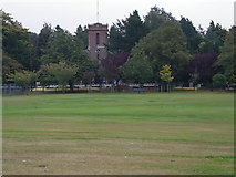
Sarisbury is a village to the west of Park Gate within the borough of Fareham, Hampshire, in the south of England.[1] Its focal point, The Green, originated as a tongue of land at the extremity of Titchfield Common which was left when the rest was enclosed.[2] Its focal point is still the parish church of St Paul,[3] built in 1836 to a design by Jacob Owen. In previous times it was a rural locality dependent on fruit growing, but is now largely populated by urban workers[citation needed] who commute to Fareham, Southampton or even London from the nearby Swanwick railway station. At the 2011 Census the population of the ward was 7,385.[4]
References
Wikimedia Commons has media related to Sarisbury.
- ^ "Fareham Borough Council: Sarisbury". Retrieved 13 October 2017.
- ^ "The Buildings of Hampshire and the Isle of Wight" Pevsner,N: Harmondsworth, Penguin, 1967 ISBN 0-14-071032-9
- ^ Church Web Site
- ^ (2011 Census. Ward)"Fareham Ward population 2011". Neighbourhood Statistics. Office for National Statistics. Retrieved 9 January 2016.
50°52′22″N 1°17′15″W / 50.872835°N 1.287574°W
