
Sathenahalli
.jpg)
13°03′26″N 76°20′21″E / 13.057344°N 76.339075°E Sathenahalli is a small village in Hassan district of India.
Location
Sathenahalli comes on the Mysore - Arsikere highway. It comes under Channarayapatna taluk of Hassan district in Karnataka state, India. [1] The village is located immediately Channarayapatna junction.[2]
Economy
The village is completely agrarian in nature. In 2015, the village recorded the highest rainfall in the region.[3]
Postal Code
There is a post office in the village and the PIN code i 573212.[4]
Image gallery
-
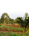 Sathenahalli
 -
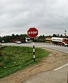 Highway Junction
.jpg)

See also
References
- ^ https://www.google.co.in/maps/place/13%C2%B003'26.4%22N+76%C2%B020'20.7%22E/@13.0573492,76.3368863,17z/data=!3m1!4b1!4m5!3m4!1s0x0:0x0!8m2!3d13.057344!4d76.339075
- ^ http://www.onefivenine.com/india/villages/Hassan/Channarayapatna/Sathenahalli
- ^ http://timesofindia.indiatimes.com/city/mangaluru/Sathenahalli-in-Hassan-records-highest-rainfall-of-71mm/articleshow/48068548.cms
- ^ http://www.onefivenine.com/india/villages/Hassan/Hassan/Sathenahalli