Schönthal
Schönthal | |
|---|---|
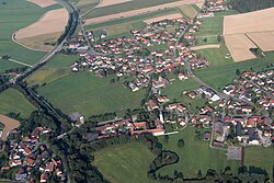
 Aerial view | |
Location of Schönthal within Cham district  | |
| Coordinates: 49°21′N 12°36′E / 49.350°N 12.600°E | |
| Country | Germany |
| State | Bavaria |
| Admin. region | Oberpfalz |
| District | Cham |
| Government | |
| • Mayor (2020–26) | Ludwig Wallinger[1] (CSU) |
| Area | |
| • Total | 43.70 km2 (16.87 sq mi) |
| Elevation | 453 m (1,486 ft) |
| Population (2022-12-31)[2] | |
| • Total | 1,965 |
| • Density | 45/km2 (120/sq mi) |
| Time zone | UTC+01:00 (CET) |
| • Summer (DST) | UTC+02:00 (CEST) |
| Postal codes | 93488 |
| Dialling codes | 0 99 78 |
| Vehicle registration | CHA |
| Website | www.gemeinde-schoenthal.de |
Schönthal is a municipality in the district of Cham in Bavaria in Germany.
It was formerly the location of Schönthal Priory, secularised in 1802.
References[edit]
- ^ Liste der ersten Bürgermeister/Oberbürgermeister in kreisangehörigen Gemeinden, Bayerisches Landesamt für Statistik, 15 July 2021.
- ^ Genesis Online-Datenbank des Bayerischen Landesamtes für Statistik Tabelle 12411-003r Fortschreibung des Bevölkerungsstandes: Gemeinden, Stichtag (Einwohnerzahlen auf Grundlage des Zensus 2011) (Hilfe dazu).


