Jump to content

Sexton, Iowa

Coordinates: 43°04′58″N 94°05′21″W / 43.08278°N 94.08917°W / 43.08278; -94.08917
From Wikipedia, the free encyclopedia

This is an old revision of this page, as edited by Illegitimate Barrister (talk | contribs) at 15:23, 15 January 2018 (clean up, replaced: Political divisions of the United States|State → U.S. state|State, List of countries| → List of sovereign states|, United States → United States using AWB). The present address (URL) is a permanent link to this revision, which may differ significantly from the current revision.

Sexton, Iowa
Lost town
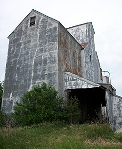
Sexton elevator
Sexton elevator
Sexton, Iowa is located in Iowa
Sexton, Iowa
Sexton, Iowa
Sexton's position in Iowa.
Coordinates: 43°04′58″N 94°05′21″W / 43.08278°N 94.08917°W / 43.08278; -94.08917
Country United States
State Iowa
CountyKossuth
Post Office openedAugust 20, 1888
Elevation
370 m (1,220 ft)
Time zoneUTC-6 (Central (CST))
 • Summer (DST)UTC-5 (CDT)
GNIS feature ID461516[1]

Sexton, Iowa was a city in Irvington Township, Kossuth County, Iowa, United States. It is located at the intersection of U.S. Route 18 and Kossuth CR P60.

Sexton was platted in 1889.[2] The town contained a post office from August 1888 until May 1974.[3]

Today

A few houses, a Racer's Bar and Grill and the Sexton elevator are all that remain of Sexton. There is now a census-designated place named Sexton used by the United States Census Bureau to count the remaining residents.

References

  1. ^ "Feature Detail Report for: Sexton." USGS. URL Retrieved June 26, 2010.
  2. ^ Reed, Benjamin F. (1913). History of Kossuth County, Iowa, Volume 1. S. J. Clarke Publishing Company. p. 589.
  3. ^ "Feature Detail Report for: Sexton Post Office (historical)." USGS. URL Retrieved June 26, 2010.