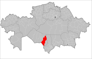
Shieli District
Shieli | |
|---|---|
District | |
| Шиелі ауданы | |
 | |
| Coordinates: 44°10′12″N 66°18′00″E / 44.17000°N 66.30000°E | |
| Country | Kazakhstan |
| Region | Kyzylorda Region |
| Administrative center | Shieli |
| Government | |
| • Akim | Nurzhan Akhatov[1] |
| Population (2013)[2] | |
| • Total | 78,427 |
| Time zone | UTC+6 (East) |
Shieli (Kazakh: Шиелі ауданы, Şielı audany) is a district of Kyzylorda Region in southern Kazakhstan. The administrative center of the district is the urban-type settlement of Shieli.[3] Population: 78,427 (2013 estimate);[2] 73,896 (2009 Census results);[4] 75,306 (1999 Census results).[4]
Shieli district is located in the middle reaches of the ancient Syr Darya River. In the eastern side there are the ancient cities of Sighnaq, Bestam, known to all, in the southern side the ancient Karatau mountains stretch. Further, the Sarysu River, originating in the Arch and Telikul, is a witness to many historical events. The western part of the district is in contact with the regional center, and the northern part with Kyzylkum, famous for its winds.
References
[edit]- ^ "Назначен аким Шиелийского района Кызылординской области". 2022-07-16.
- ^ a b "Население Республики Казахстан" (in Russian). Департамент социальной и демографической статистики. Retrieved 27 December 2013.
- ^ www.geonames.de Subdivisions of Kazakhstan in local languages
- ^ a b "Население Республики Казахстан" [Population of the Republic of Kazakhstan] (in Russian). Департамент социальной и демографической статистики. Retrieved 8 December 2013.

