Shimokita Peninsula

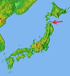
The Shimokita Peninsula (下北半島, Shimokita-hantō) is the remote northeastern cape of the Japanese island of Honshū, stretching out towards Hokkaidō. Administratively the area is a part of Aomori Prefecture.
Shaped like an axe pointing west, the peninsula has a thin "axe handle" connecting the mountainous "axe blade" to the mainland. The coasts maintain a thin scattering of population but the interior is practically uninhabited.
Shimokita is best known as the site of Mount Osore, the mythical Japanese location of the entrance to Hell. The lush Yagen Valley, known for its hot springs, is also located in Shimokita, as is Hotokegaura, wind-carved cliffs said to resemble Buddhas, and the village of Rokkasho, home to a range of nuclear facilities.

External links
41°32′47″N 140°54′47″E / 41.546488°N 140.913048°E (Ōmazaki(大間崎):Northernmost point) 41°25′52″N 141°27′43″E / 41.431015°N 141.461892°E (Shiriyazaki(尻屋崎):the northeast point)
