
Sidi Okba

Sidi Okba (also Sidi Uqba - Arabic: سيدي عقبة) is a locality in the Biskra Province, Algeria. It was named after the Muslim General Uqba ibn Nafi who died there in 683 AD. The nearest big city is Biskra which is located 18 km away.
Sidi Okba sits on an oasis. In 1911 it was described by Baedeker as "the religious center of the Zab". Baedeker stated that the town founded by pilgrims visiting the tomb of a man named Sidi Okba who died in a nearby town called Thouda. There is a mosque in town, which is the oldest in the country. Inside the mosque is the tomb and a Muslim law school.[1]
Gallery
-
![Sidi Okba Oasis, 1930 [2]](//upload.wikimedia.org/wikipedia/commons/thumb/c/c1/Entrance_to_Sidi_Okba.jpg/120px-Entrance_to_Sidi_Okba.jpg) Sidi Okba Oasis, 1930 [2]
Sidi Okba Oasis, 1930 [2] -
 Sidi Okba Street Scene, 1924
 -
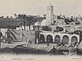 Sidi Uqba mosque, Sidi Okba 1900.
 -
 Sidi-Okba, 1962
![Sidi Okba Oasis, 1930 [2]](/wiki/File:Entrance_to_Sidi_Okba.jpg)


See also
References
- ^ "A Street, Sidi Okba, Algeria". World Digital Library. 1899. Retrieved 2013-09-26.
- ^ Tupper, William Vaughn, Entrance to Sidi Okba, (Tupper Scrapbooks Collection, 1930) Volume 1: Algeria.
34°45′N 5°54′E / 34.750°N 5.900°E
.svg)
This article about a location in Biskra Province is a stub. You can help Wikipedia by expanding it. |