
Souris Island
Nickname: Rat Island | |
|---|---|
 Souris Island | |
| Geography | |
| Location | Seychelles, Indian Ocean |
| Coordinates | 4°37′S 55°30′E / 4.617°S 55.500°E |
| Archipelago | Inner Islands, Seychelles |
| Adjacent to | Indian Ocean |
| Administration | |
| Demographics | |
| Population | 0 |
| Additional information | |
| Time zone | |
| ISO code | SC-05 |
| Official website | www |
Ile aux Souris is an island in Seychelles, lying in the eastern shores of Mahe.
With a 14-metre elevation ‘it stands just inside the long line of coral reef fringing the coasts of Anse Royale and Anse Bougainville. It is rocky, about 500 metres south west of Pointe au Sel. In the vicinity you can find the Seychelles university.
The island belongs to Anse Royale District.[1]
Image gallery
-
 Map 1
Map 1 -
 District Map
 -
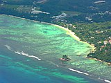 Souris Island in front of the University of Mahe


References
External links
This Seychelles location article is a stub. You can help Wikipedia by expanding it. |