South Wraxall
| South Wraxall | |
|---|---|
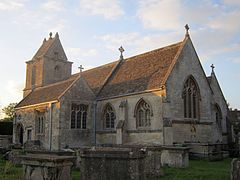
 St. James parish church | |
Location within Wiltshire | |
| Population | 438 (in 2011)[1] |
| OS grid reference | ST833655 |
| Civil parish |
|
| Unitary authority | |
| Ceremonial county | |
| Region | |
| Country | England |
| Sovereign state | United Kingdom |
| Post town | BRADFORD-ON-AVON |
| Postcode district | BA15 |
| Dialling code | 01225 |
| Police | Wiltshire |
| Fire | Dorset and Wiltshire |
| Ambulance | South Western |
| UK Parliament | |
South Wraxall is a village and a civil parish in Wiltshire, England, 2.5 miles (4.0 km) north of Bradford on Avon. The village is to the east of the B3109 road from Bradford on Avon to Corsham.
The parish includes the village of Lower Wraxall, to the south of South Wraxall; one field separates the two villages. The hamlet of Bradford Leigh is in the southeast of the parish.
History
The name comes from old English wrocc, meaning a buzzard, although it was also used as a personal name. Its name was first mentioned in 1468 as Suthwroxhall, distinguishing it from North Wraxall which is 6 miles (9.7 km) away. Other spellings of the name included wroxhal (1227) and wrokeshal (1242). Nevertheless, South Wraxall was not mentioned in Domesday Book, as it was grouped in with Bradford on Avon.
The civil parish of South Wraxall was created in 1894, together with the parishes of Holt, Winsley and Limpley Stoke all being allotted from the former parish of Bradford Without.
Most of the buildings of South Wraxall are of the 17th and 18th centuries, built from locally quarried dressed stone, or stone rubble construction with stone slates. Besides quarrying, the main occupation around the area was agriculture, including shepherding; there were also weavers in the early 19th century, and some clothworkers by the mid-19th century.
Notable buildings
South Wraxall Manor is a Grade I listed country house dating from the early 15th century. The manor farmhouse is also Grade I listed.[2]
St. James parish church is Grade II* listed.[3] Its tower dates from the 14th century but the rest was rebuilt in 1882-1883 in late Perpendicular Gothic style.
Amenities
There are no longer any shops in the village and the school, built as a National school in 1841, closed in 1972.[4] The school building now serves as the Village Hall. The Longs Arms public house is in the centre of the village. South Wraxall Club is located in Lower South Wraxall.
References
- ^ "Wiltshire Community History - Census". Wiltshire Council. Retrieved 2 May 2015.
- ^ Historic England. "Manor Farmhouse, South Wraxall (1021854)". National Heritage List for England. Retrieved 2 May 2015.
- ^ Historic England. "Church of St James, South Wraxall (1021864)". National Heritage List for England. Retrieved 2 May 2015.
- ^ "Church of England School, South Wraxall". Wiltshire Community History. Wiltshire Council. Retrieved 2 May 2015.
External links
- Wiltshire Council - Wiltshire Community History
- Wiltshire Council - Church Information
- South Wraxall village blog
 Media related to South Wraxall at Wikimedia Commons
 Media related to St James' Church, South Wraxall at Wikimedia Commons

