
Spean Praptos
Spean Praptos | |
|---|---|
 The bridge's corbel arches | |
| Coordinates | 13°07′36″N 104°20′20″E / 13.12667°N 104.33889°E |
| Carries | Road traffic |
| Crosses | Chickreng River |
| Locale | Siem Reap Province, Cambodia |
| Characteristics | |
| Design | Corbel arch |
| Material | Stone |
| History | |
| Construction start | 12th century |
| Location | |
 | |
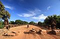
Spean Praptos (Khmer: ស្ពានព្រះទិស, also known as Kampong Kdei Bridge ស្ពានកំពង់ក្ដី) on the road from Angkor to Phnom Chisor,[1] Cambodia, used to be the longest corbeled stone-arch bridge in the world, with more than twenty narrow arches spanning 285 ft (87m). The bridge was built in the 12th century during the reign of King Jayavarman VII. It is one of the few Khmer empire era bridges to have survived to the modern day.
Several other bridges on the same model are visible: in the Angkor site (Spean Memai), Spean Thma on the former path of the Siem Reap river between Angkor Thom and the Eastern Baray, and at several locations of the former empire.
Gallery
-
 Spean Praptos
 -
 Spean Praptos front view
 -
 The bridge is depicted on the Cambodian 5,000 riel bank note


References
- ^ Rooney, 2005, pp.391-392
Bibliography
- Rooney, Dawn F. (2005). Angkor: Cambodia's wondrous khmer temples (5th ed.). Odissey. ISBN 978-962-217-727-7.
External links
![]() Media related to Spean Praptos at Wikimedia Commons
Media related to Spean Praptos at Wikimedia Commons
This article about a bridge in Cambodia is a stub. You can help Wikipedia by expanding it. |