
Spytihněv
Spytihněv | |
|---|---|
Municipality | |
 Church of the Assumption of the Virgin Mary | |
 Flag  Coat of arms | |
 Spytihněv | |
| Coordinates: 49°8′36″N 17°29′40″E / 49.14333°N 17.49444°E | |
| Country | |
| Region | Zlín |
| District | Zlín |
| Area | |
| • Total | 9.64 km2 (3.72 sq mi) |
| Elevation | 186 m (610 ft) |
| Population | |
| • Total | 1,677 |
| • Density | 170/km2 (450/sq mi) |
| Postal code | 763 64 |
| Website | http://www.spytihnev.cz |
Spytihněv is a village and municipality (obec) in Zlín District in the Zlín Region of the Czech Republic.
The municipality covers an area of 9.64 square kilometres (3.72 sq mi), and has a population of 1,677.
Spytihněv lies approximately 17 kilometres (11 mi) south-west of Zlín and 246 km (153 mi) south-east of Prague.
Gallery
-
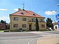 Municipal office
 -
 Statue of John the Evangelist
 -
 Weir on the Morava River
 -
 Molo on the Baťa canal


References
This Zlín Region location article is a stub. You can help Wikipedia by expanding it. |