
St. Clara, West Virginia
St. Clara, West Virginia | |
|---|---|
| Country | United States |
| State | West Virginia |
| County | Doddridge |
| Time zone | UTC-5 (Eastern (EST)) |
| • Summer (DST) | UTC-4 (EDT) |
| GNIS feature ID | 1555554U.S. Geological Survey Geographic Names Information System: St. Clara, West Virginia |
St. Clara is an unincorporated community in central Doddridge County, West Virginia, US. Its elevation is 850 feet (254 m).[1]
An early postmaster gave the community the name of his wife, Clara DisBebar.[2] Located at St. Clara is the Gamsjager-Wysong Farm, listed on the National Register of Historic Places in 1986.[3]
References
- ^ U.S. Geological Survey Geographic Names Information System: St. Clara, West Virginia, Geographic Names Information System, 1980-06-27. Accessed 2011-06-21.
- ^ Kenny, Hamill (1945). West Virginia Place Names: Their Origin and Meaning, Including the Nomenclature of the Streams and Mountains. Piedmont, WV: The Place Name Press. p. 548.
- ^ "National Register Information System". National Register of Historic Places. National Park Service. March 13, 2009.
Municipalities and communities of Doddridge County, West Virginia, United States | ||
|---|---|---|
| Town | 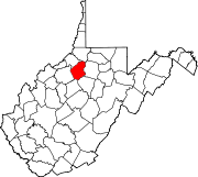 | |
| Unincorporated communities | ||
This article about a location in Doddridge County, West Virginia is a stub. You can help Wikipedia by expanding it. |