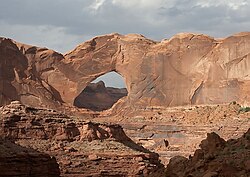
Stevens Arch
Appearance
This article has multiple issues. Please help improve it or discuss these issues on the talk page. (Learn how and when to remove these messages)
|
Stevens Arch | |
|---|---|
 View of the arch | |
| Coordinates: 37°26′02″N 110°58′46″W / 37.4338794°N 110.9793218°W | |
| Location | Kane County, Utah, United States |
| Dimensions | |
| • Length | 220 ft (67 m) |
| • Height | 160 ft (49 m) |
Stevens Arch is a large natural arch located in Grand Staircase–Escalante National Monument, Utah. The bridge has a span of 220 feet (67.06 metres), making it the fourteenth longest natural arch span in the United States as measured by the Natural Arch and Bridge Society.[1]
Access
[edit]Stevens Arch can be accessed via an 8-mile round trip hike with a total elevation gain of about 1500 feet (457.2 m).[2]
Geology
[edit]The arch comprises Navajo Sandstone and stands above the Escalante River.[3] The arch is located in Escalante Canyon at its junction with Stevens Canyon, just upstream from Coyote Gulch.
References
[edit]- ^ "Stevens Arch". Natural Arch and Bridge Society. Retrieved October 31, 2023.
- ^ "Stevens Arch". Outdoor project. Retrieved October 31, 2023.
- ^ "Hike Guide: Inside Stevens Arch". Acrossutah.com. February 12, 2020. Retrieved October 31, 2023.[better source needed]


