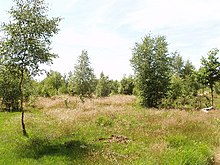
Stoke Common
Appearance
| Site of Special Scientific Interest | |
 | |
| Location | Buckinghamshire |
|---|---|
| Grid reference | SU985853 |
| Interest | Biological |
| Area | 83.1 hectares |
| Notification | 1984 |
| Location map | Magic Map |
Stoke Common is an 83.1 hectare Site of Special Scientific Interest in Stoke Poges in Buckinghamshire. It is registered common land, and it is owned by a charitable trust, with the City of London Corporation as the main funder and trustee.[1][2][3]
The site is a last remnant of a large heath, and is on glacial gravel over London clay, with some parts permanently waterlogged. Periodic burning helps to manage the land. There are small areas of birch, pine and mixed woodland, with several ponds. There is a rich invertebrate fauna, especially moths, and the dusky cockroach and rare bog bush cricket have also been recorded.[1]
There is access from Stoke Common Road and Gerrards Cross Road.[2]
References
- ^ a b "Stoke Common citation" (PDF). Sites of Special Scientific Interest. Natural England. Retrieved 12 October 2015.
- ^ a b "Map of Stoke Common". Sites of Special Scientific Interest. Natural England. Retrieved 12 October 2015.
- ^ "Burnham Beeches and Stoke Common". City of London. Retrieved 12 October 2015.
