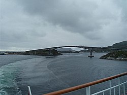
Stokkøy Bridge
Stokkøy Bridge Stokkøybrua | |
|---|---|
 View of the bridge | |
| Coordinates | 64°02′51″N 10°02′28″E / 64.0474°N 10.0412°E |
| Carries | File:Riksvei 723.svg Rv723 |
| Crosses | Stokksundet |
| Locale | Åfjord, Norway |
| Characteristics | |
| Design | Cantilever bridge |
| Material | Concrete |
| Total length | 525 metres (1,722 ft) |
| Longest span | 206 metres (676 ft) |
| Clearance below | 30 metres (98 ft) |
| History | |
| Construction start | 1998 |
| Construction end | 2000 |
| Inaugurated | December 2000 |
| Location | |
 | |
Stokkøy Bridge (Norwegian: Stokkøybrua) is a concrete cantilever bridge that crosses the Stokksundet strait between the mainland and Stokkøya in the municipality of Åfjord in Sør-Trøndelag county, Norway. The bridge starts near Revsnes on the mainland and goes north to the island of Stokkøya near the village of Harsvika.[1]
The 525-metre (1,722 ft) long bridge was opened in December 2000. The bridge has 6 spans, the longest of which is 206 metres (676 ft). The clearance to the sea is 30 metres (98 ft). Stokkøy Bridge cost around 120 million kr to build.[2]
See also
- List of bridges in Norway
- List of bridges in Norway by length
- List of bridges
- List of longest bridges in the world
References
- ^ Store norske leksikon. "Stokkøybrua" (in Norwegian). Retrieved 2011-01-04.
- ^ Merzagora, Eugenio A. (ed.). "Road Viaducts & Bridges in Norway (> 500 m)". Norske bruer og viadukter. Retrieved 2011-01-04.
External links
