Storebjørn
Appearance
| Storebjørn | |
|---|---|
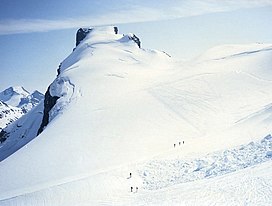
 Summit seen from the north. | |
| Highest point | |
| Elevation | 2,222 m (7,290 ft)[1] |
| Prominence | 804 m (2,638 ft)[1] |
| Isolation | 8.7 km (5.4 mi)[1] |
| Coordinates | 61°32′53″N 8°08′13″E / 61.54815°N 8.13708°E[2] |
| Geography | |
| Location | Innlandet, Norway |
| Parent range | Jotunheimen |
| Topo map | 1518 II Galdhøpiggen |
| Climbing | |
| First ascent | 14 August 1884, Carl Christian Hall and Mathias Soggemoen |
Storebjørn (lit. 'Big Bear') is a mountain in Lom Municipality in Innlandet county, Norway. The 2,222-metre (7,290 ft) tall mountain is located in the Jotunheimen mountains within Jotunheimen National Park. The mountain sits about 40 kilometres (25 mi) southwest of the village of Fossbergom and about 33 kilometres (21 mi) northeast of the village of Øvre Årdal. The mountain lies in the Smørstabbtindene mountains and it is surrounded by several other notable mountains including Rundhøe to the northeast; Stetinden and Stehøi to the east; Gravdalstinden to the south; Kalven to the northwest; and Veslebjørn, Sokse, Kniven, and Store Smørstabbtinden to the north.[1]
See also
[edit]References
[edit]- ^ a b c d "Storebjørn". PeakVisor.com. Retrieved 12 May 2022.
- ^ "Storebjørn, Lom" (in Norwegian). yr.no. Retrieved 12 May 2022.


