
Strone, Cowal
Strone
| |
|---|---|
 Strone Point | |
 Strone Location within Argyll and Bute | |
| OS grid reference | NS 19300 80700 |
| Council area |
|
| Lieutenancy area |
|
| Country | Scotland |
| Sovereign state | United Kingdom |
| Post town | DUNOON, ARGYLL |
| Postcode district | PA23 |
| Dialling code | 01369 |
| UK Parliament |
|
| Scottish Parliament |
|
Strone; (Scottish Gaelic: An t-Sròn) is a village, on the Cowal peninsula in Argyll and Bute in the Scottish Highlands at the point where the north shore of the Holy Loch becomes the west shore of the Firth of Clyde. The village lies within the Loch Lomond and The Trossachs National Park.[1]
Origin of name
The name comes from the Scottish Gaelic for nose, and applies to the hill above the village as well as to Strone Point. It adjoins the settlement of Kilmun on the loch, and the village of Blairmore on Loch Long. It used to have its own pier (built in 1847) and was a regular stop for the Clyde steamer services.[2]
The Village
A high road on the side of the hill serves additional houses including Dunselma, a Scottish baronial style house above the point. It was built as a sailing lodge for the wealthy Coats family (proprietors of the eponymous Paisley mills) in 1885-7 by the Paisley firm of Rennison and Scott.[3][4] It was bought by the Scottish Youth Hostels Association in 1941, and they used it as a hostel until 1965. It still forms a landmark clearly visible from the other side of the Clyde, and is a Category A listed building.[3][5]
It is on the A880 road.

Gallery
-
 Strone Church - geograph.org.uk - 1191149
 -
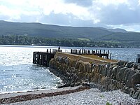 Strone Pier (derelict) - geograph.org.uk - 865180
 -
 Strone Hill from the Firth of Clyde - geograph.org.uk - 1000964
 -
 Strone Terrace - geograph.org.uk - 865190

_-_geograph.org.uk_-_865180.jpg)


References
- ^ http://www.lochlomond-trossachs.org/rr-content/uploads/2016/07/Downloadable-map-of-Loch-Lomond-and-the-Trossachs-National-Park.pdf
- ^ Deayton, Alistair (2013). Clyde Coast Piers. Amberley Publishing. ISBN 9781848684270.
- ^ a b "Strone, Dunselma LB5075". Historic Environment Scotland. Retrieved 26 August 2018.
- ^ "Basic Site Details: Dunselma". Dictionary of Scottish Architects. Retrieved 26 August 2018.
- ^ "Listed Building Report". Hsewsf.sedsh.gov.uk. 1988-02-02. Retrieved 2012-04-05.
External links
- Map sources for Strone, Cowal
- Gaelic place names of Scotland - website
- Towns in the Dunoon & Cowal area - website
- Geograph - website
- The Loch Lomond and The Trossachs National Park - website