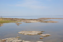
Sub-Cambrian peneplain
Appearance

The sub-Cambrian peneplain is a geomorphic unit covering large swathes of Fennoscandia. It consists in a series of discontiguous low relief zones that are at some locations covered by a sedimentary rock cover dating to the Cambrian. Close to the cover rocks the exposed parts of the peneplain are extraordinarily flat.[1] In Norway the peneplain is apparently disrupted by vertical displacement along faults, following an NNE-SSW orientation.[2]
See also
References
- ^ Lidmar-Bergström, Karna; Bonow, Johan M.; Japsen, Peter (2013). "Stratigraphic Landscape Analysis and geomorphological paradigms: Scandinavia as an example of Phanerozoic uplift and subsidence". Global and Planetary Change. 100: 153–171.
{{cite journal}}:|access-date=requires|url=(help) - ^ Jarsve, Erlend M.; Krøgli, Svein Olav; Etzelmüller, Bernd; Gabrielsen, Roy H. (2014). "Automatic identification of topographic surfaces related to the sub-Cambrian
peneplain (SCP) in southern Norway—Surface generation algorithms and implications". Geomorphology. 211. Elsevier: 89–99.
{{cite journal}}:|access-date=requires|url=(help); line feed character in|title=at position 77 (help)
