Sunne Municipality
Appearance
Sunne Municipality
Sunne kommun | |
|---|---|
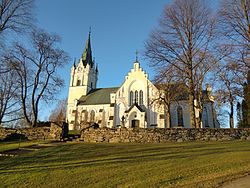
 Sunne church in Värmland, Sweden | |
 | |
| Country | Sweden |
| County | Värmland County |
| Seat | Sunne |
| Area | |
| • Total | 1,448.25 km2 (559.17 sq mi) |
| • Land | 1,288.11 km2 (497.34 sq mi) |
| • Water | 160.14 km2 (61.83 sq mi) |
| Area as of 1 January 2014. | |
| Population (31 December 2023)[2] | |
| • Total | 13,366 |
| • Density | 9.2/km2 (24/sq mi) |
| Time zone | UTC+1 (CET) |
| • Summer (DST) | UTC+2 (CEST) |
| ISO 3166 code | SE |
| Province | Värmland |
| Municipal code | 1766 |
| Website | www |
Sunne Municipality (Template:Lang-sv) is a municipality in Värmland County in west central Sweden. Its seat is located in the town of Sunne.
The present municipality was created in 1971 when the market town (köping) Sunne (instituted in 1920) was amalgamated with Gräsmark and Lysvik.
Localities
Karlstad, which has an international airport, is the nearest large city.
References
- ^ "Statistiska centralbyrån, Kommunarealer den 1 januari 2014" (in Swedish). Statistics Sweden. 2014-01-01. Archived from the original (Microsoft Excel) on 2016-09-27. Retrieved 2014-04-18.
- ^ "Folkmängd och befolkningsförändringar - Kvartal 4, 2023" (in Swedish). Statistics Sweden. February 22, 2024. Retrieved February 22, 2024.
External links
Wikimedia Commons has media related to Sunne.
- Official website
- Brobytornet - Project site

