
Swartberg Pass
You can help expand this article with text translated from the corresponding article in French. (November 2010) Click [show] for important translation instructions.
|

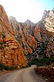
The Swartberg Pass on the R328 run through the Swartberg mountain range (black mountain in English) which runs roughly east-west along the northern edge of the semi-arid area called the Little Karoo in the Western Cape province of South Africa.
History
The Swartberg pass was built between 1881 and 1888 by Thomas Bain, son of the famous Andrew Geddes Bain who built Bain's Kloof Pass and many more. It followed their earlier construction of another pass in 1858, the Meiringspoort, through the same mountains but further east.[1]
It was built using convict labour, and opened on 10 January 1888. The dry-stone retaining walls, supporting some of its picturesque hairpin bends, are still in place and almost 120 years old.
Geography
To the north of the range lies the other large semi-arid area in South Africa, the Great Karoo. Much of the Swartberg is part of a UNESCO World Heritage Site.
The pass runs between Oudtshoorn in the south and Prince Albert in the north. The pass is not tarred and can be a little treacherous after rain, but offers spectacular views over the Little Karoo to the south and the Great Karoo to the north. The plant life along the pass is very interesting, many hundreds of species being found on the Swartberg.[2]
The top of the pass is at 33°21′8″S 22°2′45″E / 33.35222°S 22.04583°E.
Geology
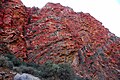
The Swartberg mountains are amongst the best exposed fold mountain chains in the world, and the pass slices through magnificently scenic geological formations.[3] The contortions in the rock display astonishing anticlines and synclines, and the vivid coloration of the surrounding Quartzite is remarkable.
The pass is especially famous due to the spectacular geology that is exposed at its Northern end. Here, seven-hundred-metre-high quartzite cliffs of the upper Table Mountain Group can be seen, and these are often tilted through 90 degrees (sometimes even more).[4] Arguably the most famous of all these cliff faces is the spectacular 'Wall of Fire'.
Gallery
-
 Swartberg Pass
 -
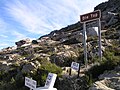 Top the Swartberg Pass
 -
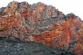 Swartberg Pass Rock Formation
 -
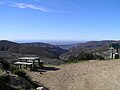 View North from the Top of the Pass
 -
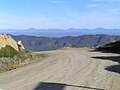 View South from the Top of the Pass
 -
 The Swartberg Mountains
 -
 Swartberg Pass


References
- ^ G. Ross: Romance of Cape Mountain Passes. New Africa Books. 2004. ISBN 0864866631, 9780864866639.
- ^ http://drakensberg-tourist-map.com/Swartberg.html
- ^ Geological Journeys. Norman, N. and Whitfield, G. 2006
- ^ Geological Journeys. Norman, N. and Whitfield, G. 2006
- http://www.tourismcapetown.co.za/ctru/content/en/us/full-article?oid=5633&sn=Detail&pid=2995&Cape-Karoo-and-Klein-Karoo-Mountain-Passes
- http://drakensberg-tourist-map.com/Swartberg.html