Jump to content

Szentendre Island

Coordinates: 47°44′50″N 19°06′32″E / 47.74722°N 19.10889°E / 47.74722; 19.10889
From Wikipedia, the free encyclopedia

This is an old revision of this page, as edited by 134.76.201.146 (talk) at 15:04, 20 July 2015 (thumb|One end of Szentendre Island is visible on the left.). The present address (URL) is a permanent link to this revision, which may differ significantly from the current revision.

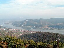
One end of Szentendre Island is visible on the left.

Szentendre Island is an island in the Danube River between the Danube Bend and Budapest in Hungary. It is 31 km long with an area of 56 km². Several villages as located on the island including (from north to south) Kisoroszi, Tahitótfalu, Pócsmegyer, Surány, Szigetmonostor and Horány.

47°44′50″N 19°06′32″E / 47.74722°N 19.10889°E / 47.74722; 19.10889