Taehongdan County
Taehongdan County
대홍단군 | |
|---|---|
| Korean transcription(s) | |
| • Chosŏn'gŭl | 대홍단군 |
| • Hancha | 大紅湍郡 |
| • McCune-Reischauer | Taehongdan-gun |
| • Revised Romanization | Daehongdan-gun |
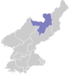
 Map of Ryanggang showing the location of Taehongdan | |
| Country | North Korea |
| Province | Ryanggang |
| Administrative divisions | 1 ŭp, 9 workers' districts |
| Area | |
| • Total | 680.9 km2 (262.9 sq mi) |
| Population (2008 census) | |
| • Total | 35,596 |
| • Density | 52/km2 (140/sq mi) |
Taehongdan County is a kun, or county, in Ryanggang province, North Korea. It was originally part of Musan County.
The Taehongdan Revolutionary Battle Site there commemorates battles waged by Kim Il Sung in the area during the anti-Japanese struggle.[1]
Geography
[edit]To the north, Taehongdan looks across the Tumen River at China. It stands on the northwest edge of the Paektu Plateau. The highest of its many peaks is Changchongsan (Korean: 장청산). The chief river is the Tumen. Some 91% of the county's area is taken up by forestland. Due to its inland location, Taehongdan has a continental climate with cold winters.
Administrative divisions
[edit]Taehongdan county is divided into 1 ŭp (town) and 9 rodongjagu (workers' districts):
|
Economy
[edit]Logging is an important local industry. Agriculture is also key, with the county leading the nation in potato production and also producing barley, wheat and soybeans. Livestock are also raised in the county, and there is some manufacturing.
Transportation
[edit]Taehongdan is served by roads, but not by rail.
See also
[edit]References
[edit]- ^ "Taehongdan Revolutionary Battle Site". KCNA. 23 May 2011. Archived from the original on 12 October 2014.
External links
[edit]- Changed Taehongdan Plain picture album at Naenara
- In Korean language online encyclopedias:

