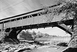
Taftsville Covered Bridge
Taftsville Bridge | |
|---|---|
 HABS photo of Taftsville Bridge, 2004 | |
| Coordinates | 43°37′51″N 72°28′04″W / 43.63082°N 72.46791°W |
| Carries | Covered Bridge Road between Woodstock Road & Upper River Road |
| Crosses | Ottauquechee River |
| Locale | Woodstock, Vermont |
| Characteristics | |
| Design | modified multiple-kingpost truss with semi-independent arch |
| Material | Wood |
| Total length | 189 feet (57.6 m) |
| Width | 20 feet (6.1 m) |
| No. of spans | 2 |
| Piers in water | 1 |
| History | |
| Designer | Solomon Emmons III |
| Opened | 1836 |
| Location | |
 | |
The Taftsville Bridge is a timber-framed covered bridge which spans the Ottauquechee River in the Taftville village of Woodstock, Vermont in the United States.[1] Built in 1836 and exhibiting no influence from patented bridge designs,[1] it is among the oldest remaining covered bridges both in Vermont[2] and the nation as a whole.[3]
History
The village of Taftsville was first settled more than 70 years before the construction of the modern Taftsville Bridge.[4] Stephen Taft, after whom the village was ultimately named, arrived in the early 1790s. Within a decade of Taft's arrival, he and his brother had established a number of mills and the increasingly busy settlement required a bridge over the Ottauquechee River. The first bridge was washed away during a flood in 1807, with its replacement also falling to floodwaters in 1811. When the third bridge at the site was again washed away during an 1828 flood, a distinguished local by the name of Solomon Emmons III was contracted to build a more resilient crossing. His timber-framed, covered bridge was completed in 1836 and still stands today as the modern Taftsville Bridge.[1]
The Taftsville Bridge was extensively damaged by flooding caused by Hurricane Irene in 2011, and was closed for two years while repairs took place. It was reopened in September 2013.[5]
Architecture
Unlike many extant covered bridges which are based upon patented bridge designs, the Taftsville Bridge reflects an earlier "craftsman" bridge-building tradition that was possibly influenced by designs found in Switzerland. While the incorporation of laminated arches in the bridge structure is generally indicative of the well-known Burr arch-truss, which was patented in the United States in 1817, the resemblance is purely superficial. Instead, the unusual design of the Taftsville Bridge is better described as a "modified multiple kingpost truss with semi-independent arches".[1]
Taftsville Bridge reaches a total of 189 feet (58 m) over the Ottauquechee River with two spans of 89 feet (27 m) and 100 feet (30 m) from either river bank to a central pier in the river gorge. The bridge measures 20 feet (6.1 m) in width, providing an interior roadway that is 16 feet (4.9 m).[6]
See also
- List of Vermont covered bridges
- National Register of Historic Places listings in Windsor County, Vermont
- List of bridges on the National Register of Historic Places in Vermont
References
- ^ a b c d "Historic American Engineering Record: Taftsville Bridge, HAER No. VT 30" (PDF). National Park Service. United States Department of the Interior. Retrieved 14 June 2016.
- ^ Bickel, Hank. "Vermont Covered Bridges: Taftsville Bridge VT-14-12". Covered Bridges of the Northeast USA. Hank Bickel. Retrieved 14 June 2016.
- ^ Conwill, Joseph D (2014). Covered Bridges. Bloomsbury Publishing. ISBN 9781784420109.
- ^ Dana, Henry Swan (1889). History of Woodstock, Vermont. Houghton, Mifflin. p. 98. Retrieved 14 June 2016.
- ^ "Reconnecting with the Taftsville Covered Bridge". Happy Vermont. July 11, 2014. Retrieved 2016-09-03.
- ^ Hugh H. Henry (August 28, 1973). "NRHP Nomination:Taftsville Covered Bridge" (Document). National Park Service.
{{cite document}}: Unknown parameter|work=ignored (help)
- Covered bridges in Vermont
- Covered bridges on the National Register of Historic Places in Vermont
- Bridges completed in 1836
- Wooden bridges in Vermont
- Buildings and structures in Windsor County, Vermont
- Transportation in Windsor County, Vermont
- Visitor attractions in Windsor County, Vermont
- Road bridges in Vermont
- National Register of Historic Places in Windsor County, Vermont
- Road bridges on the National Register of Historic Places in Vermont
