
Taki-no Castle
| Taki-no-jō Castle 滝の城 | |
|---|---|
| Tokorozawa, Saitama Prefecture, Japan | |
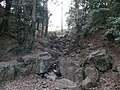
 The Taki-no-jō (Waterfall) Castle dry moat. | |
| Coordinates | 35°48′02″N 139°31′54″E / 35.80056°N 139.53167°E |
| Type | Japanese castle |
| Site information | |
| Controlled by | Oishi clan |
| Condition | Ruins |
| Site history | |
| Built | Sengoku Period |
| Built by | Ōishi Sadahisa |
| Demolished | 1590 |
Taki-no-jō Castle (滝の城, Taki-no-jō) , literally means "waterfall castle", is a flatland-hilltop Japanese castle ruin located in Tokorozawa, Saitama Prefecture. It was on a key route between the northern Kanto Plain and Hachioji.
The most recent structure was built in the 15th century by Ōishi Sadahisa and existed during the 16th century Sengoku Period of Japanese history. In 1546, the Hojo of Odawara took control and in 1569 possession passed to the Takeda.[1]
After 1590, the castle was abandoned simultaneously with the arrival of Tokugawa Ieyasu into the region, having outlived its purpose.
The castle is now a ruin with clear archeological evidence of the foundations of a number buildings and a dry moat. The castle name "Taki-no-jō", which literally means "waterfall castle" is due to an waterfall that exists on the eastern part of the castle grounds. The castle grounds now form a recreational park including walking paths, a children's play area and a baseball field. The park is called Taki-no-jō Castle Site Park (滝の城址公園, Taki-no-jō-shi Kōen).
-
 Shrine at the summit. Site of the honmaru main citadel
 -
 Creek and waterfall from which the castle was named.


Notes
- ^ Papinot, E. (1910)
References
- Papinot, E. (1910). "Historical and Geographical Dictionary of Japan." 1972 Printing. Charles E. Tuttle Company, Tokyo, ISBN 0-8048-0996-8.
- On site descriptive signage.