Teisko Airfield
Appearance
Teisko Airfield Teiskon lentokenttä | |||||||||||
|---|---|---|---|---|---|---|---|---|---|---|---|
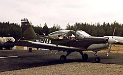
 Valmet L-70 Miltrainer at Teisko Airfield in 1983 | |||||||||||
| Summary | |||||||||||
| Airport type | Public | ||||||||||
| Owner | City of Tampere | ||||||||||
| Operator | Tampereen Vauhtipuisto ry | ||||||||||
| Location | Velaatta, Tampere, Finland | ||||||||||
| Coordinates | 61°46′23″N 024°01′31″E / 61.77306°N 24.02528°E | ||||||||||
| Map | |||||||||||
 | |||||||||||
| Runways | |||||||||||
| |||||||||||
Teisko Airfield is an airfield in the Velaatta village (in the former municipality of Teisko) in Tampere, Finland. It is located about 51 kilometres (32 mi) southwest of city centre of Tampere. The airfield was completed in 1983,[1] and it is owned by the City of Tampere and operated by Tampereen Vauhtipuisto ry.[2] Gliding and motor gliding activities have been practiced in the field.[3]
See also
[edit]References
[edit]- ^ "TIY:n historiaa" (in Finnish). Tampere: Tampereen Ilmailuyhdistys ry. Retrieved November 28, 2021.
- ^ "Tampereen Vauhtipuisto Teiskoon – Lue suunnitelmista täältä". Tamperelainen (in Finnish).
- ^ "Teisko, Finland – EFTS". VFR Suomi/Finland (in Finnish). Vantaa: Finavia. November 18, 2010. Retrieved November 28, 2021.
External links
[edit]

