
Terry Badlands WSA
| Terry Badlands WSA | |
|---|---|
| Lua error in Module:Location_map at line 526: Unable to find the specified location map definition: "Module:Location map/data/US Locator TerryWSA.png" does not exist. | |
| Location | Prairie County, Montana, USA |
| Nearest city | Terry, MT |
| Coordinates | 46°49′0″N 105°19′0″W / 46.81667°N 105.31667°W |
| Governing body | Bureau of Land Management |
The Terry Badlands WSA (also Terry Badlands) is a designated Wilderness Study Area by the Bureau of Land Management. It is located three miles north of the township of Terry, Montana.
-
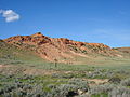 A typical ridgeline in the Terry Badlands WSA.
 -
 View of Terry from the WSA.


See also
External links
- Official Bureau of Land Management Website
- Custer Country Terry Badlands WSA Website
- Montana magazine article
This Montana-related article is a stub. You can help Wikipedia by expanding it. |