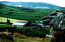
Trencrom Hill

Trencrom Hill (or Trecrobben) is a prominent hill fort, owned by the National Trust, near Lelant, Cornwall. It is crowned by an univallate Neolithic tor enclosure and was re-used as a hillfort in the Iron Age. Cairns or hut circles can be seen in the level area enclosed by the stone and earth banks.[1] The hill overlooks the Hayle Estuary and river, and Mount's Bay and St. Michael's Mount can be seen to the south.[2] The hill was recorded as Torcrobm in 1758 which is derived from Cornish "torr crobm", i.e. 'hunched bulge'.[3]
Trink lies one kilometre to the north west.
National Trust
Trencrom Hill was acquired by the National Trust as freehold on 8 August 1946 from Lieutenant Colonel G L Tyringham. The freehold was 25.568 hectares (63.18 acres).
Plaque on Hill
On ascending the hill from the North side there is a plaque in situ in the rock facing the path. It reads:
"This property was presented to the National Trust by Lt Col C L Tyringham, of Trevethoe in March 1946 & at his wish is to be regarded as a memorial to the men and women of Cornwall, who gave their lives in the service of their country during the two world wars. 1914 – 1918, 1939 – 1945"
Mythology
Trecobben, the giant of Trencrom, was supposed to have killed Cormelian (wife of Cormoran) by throwing a hammer across to St Michael's Mount.
Trencrom Hill Well
This is possibly a well constructed to service the inhabitants of the camp.
References
- ^ Dudley, P. (2008) Archaeology of the Moors, Downs and Heaths. Truro: Historic Environment Service, Cornwall County Council.
- ^ Ordnance Survey: Landranger map sheet 203 Land's End ISBN 978-0-319-23148-7
- ^ Weatherhill, Craig (2009). A Concise Dictionary of Cornish Place-Names. Westport, Co. Mayo: Evertype. ISBN 9781904808220; p. 7
