Tri-Cities metropolitan area
Tri-Cities Metropolitan Area | |
|---|---|
| Kennewick–Richland, WA Metropolitan Statistical Area | |
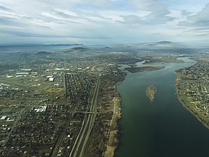
 Aerial view of Kennewick from above the Columbia River | |
 | |
| Coordinates: 46°22′N 119°16′W / 46.367°N 119.267°W | |
| Country | |
| State | |
| Largest city | Kennewick (83,921) |
| Other cities | - Pasco (77,108) - Richland (60,560) - West Richland (16,295) - Prosser (6,062) - Connell (5,450) - Benton City (3,360) - Mesa (488) - Kahlotus (190) |
| Area | |
| • Total | 2,942.5 sq mi (7,621 km2) |
| Highest elevation | 3,527 ft (1,075 m) |
| Lowest elevation | 265 ft (81 m) |
| Population (2022) | |
| • Total | 311,469 |
| • Rank | 165th in the U.S. |
| • Density | 95/sq mi (37/km2) |
| GDP | |
| • Total | $19.553 billion (2022) |
| Time zone | UTC-8 (PST) |
| • Summer (DST) | UTC-7 (PDT) |
The Kennewick–Pasco–Richland metropolitan area—colloquially referred to as the Tri-Cities metropolitan area, and officially known as the Kennewick–Richland, WA Metropolitan Statistical Area—is a metropolitan area consisting of Benton and Franklin counties in Washington state, anchored by the cities of Kennewick, Pasco, and Richland (the Tri-Cities). As of July 1, 2022, the U.S. Census Bureau estimates the population of the metropolitan area to be 311,469,[2] making it the third-largest metropolitan area located entirely in Washington, after the Seattle metropolitan area and the Spokane metropolitan area. Although it is located outside of the metropolitan area, the CDP of Burbank (located in Walla Walla County) is part of the Tri-Cities urban area.[3]
The Tri-Cities metro area is a constituent piece of the Kennewick-Richland-Walla Walla combined statistical area, which consists of the Tri-Cities (Benton and Franklin Counties) along with the Walla Walla metropolitan area (Walla Walla County).[4]
Counties
[edit]Communities
[edit]Over 50,000 inhabitants
[edit]10,001 to 50,000 inhabitants
[edit]5,001 to 10,000 inhabitants
[edit]5,000 inhabitants or fewer
[edit]Unincorporated places
[edit]Ghost towns
[edit]- Ainsworth
- Berrian
- Cactus
- East White Bluffs
- Gibbon
- Hanford (depopulated in March 1943)
- Horse Heaven
- Hover
- Wahluke
- White Bluffs (depopulated in March 1943)
- Yellepit
Demographics
[edit]| Census | Pop. | Note | %± |
|---|---|---|---|
| 1910 | 13,090 | — | |
| 1920 | 16,780 | 28.2% | |
| 1930 | 17,089 | 1.8% | |
| 1940 | 18,360 | 7.4% | |
| 1950 | 64,933 | 253.7% | |
| 1960 | 85,412 | 31.5% | |
| 1970 | 93,406 | 9.4% | |
| 1980 | 144,469 | 54.7% | |
| 1990 | 150,033 | 3.9% | |
| 2000 | 191,822 | 27.9% | |
| 2010 | 253,340 | 32.1% | |
| 2020 | 303,622 | 19.8% | |
| 2022 (est.) | 311,469 | 2.6% |
As of 2020, there were 303,622 people and 100,336 households residing within the MSA. The racial makeup of the MSA was 60% White, 32% Hispanic, 3% Asian, 2% Black, 0% Native, and 0% Islander.
The median income for a household in the MSA was $70,545. The per capita income for the MSA was $31,610.[5]
References
[edit]- ^ "Total Gross Domestic Product for Kennewick-Richland, WA (MSA)". Federal Reserve Economic Data. Federal Reserve Bank of St. Louis.
- ^ "Quick Facts: Franklin County, Washington; Benton County, Washington". census.gov. U.S. Census Bureau. Retrieved 23 May 2023.
- ^ "Tri-Cities urban area map" (PDF). United States Census Bureau. Retrieved April 19, 2019.
- ^ "Kennewick-Richland-Walla Walla, WA CSA". censusreporter.org. Census Reporter. Retrieved 30 April 2022.
- ^ "Kennewick-Richland, WA Metro Area". United States Census Bureau. Retrieved 2022-06-07.
