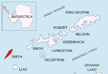
Tsarigrad Peak


Tsarigrad Peak ([Връх Цариград] Error: {{Lang-xx}}: text has italic markup (help), ‘Vrah Tsarigrad’ \'vr&h 'tsa-ri-grad\) is sharp ice-covered peak rising to 1760 m in Imeon Range, Smith Island in the South Shetland Islands, Antarctica. Overlooking Armira Glacier to the southeast.
The peak is named after the 1876 Constantinople Conference (Tsarigrad is the Bulgarian name for Constantinople) of the Great Powers that determined the Bulgarian ethnic borders as of the second half of the 19th century.
Location
Tsarigrad Peak is located at 63°00′53″S 62°34′42″W / 63.01472°S 62.57833°W, which is 2.5 km southwest of the island’s summit Mount Foster, 550 m south of Slaveykov Peak and 600 m northeast of Neofit Peak. Bulgarian mapping in 2009.
Map
- L.L. Ivanov. Antarctica: Livingston Island and Greenwich, Robert, Snow and Smith Islands. Scale 1:120000 topographic map. Troyan: Manfred Wörner Foundation, 2009. ISBN 978-954-92032-6-4
References
This article includes information from the Antarctic Place-names Commission of Bulgaria which is used with permission.
