Jump to content

Tsiombe

Coordinates: 25°18′S 45°29′E / 25.300°S 45.483°E / -25.300; 45.483
From Wikipedia, the free encyclopedia

This is an old revision of this page, as edited by Delusion23 (talk | contribs) at 23:54, 29 December 2013 (fix typos, dates, formatting, references, brackets and links, replaced: East African Time → East Africa Time using AWB). The present address (URL) is a permanent link to this revision, which may differ significantly from the current revision.

Tsiombe
town
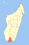
Map of former Toliara Province showing the location of Tsiombe (red).
CountryMadagascar
RegionAndroy
DistrictTsiombe
Elevation
150 m (490 ft)
Time zoneUTC3 (EAT)

Tsiombe is a town in Androy Region, Madagascar. It is situated at the Manambovo River and the Route nationale 10 and about 30 km north of the southernmost point of the island, Cape Sainte Marie.

25°18′S 45°29′E / 25.300°S 45.483°E / -25.300; 45.483