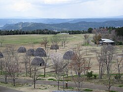
Uenohara site
Appearance
| Uenohara site 上野原遺跡 | |
|---|---|
 Uenohara Jōmon no Mori | |
 | |
| General information | |
| Address | Jōmon no Mori, Kokubuuenohara |
| Town or city | Kirishima, Kagoshima |
| Country | Japan |
| Coordinates | 31°42′43″N 130°48′7″E / 31.71194°N 130.80194°E |
| Designations | Historic Site |
The Uenohara site (上野原遺跡, Uenohara iseki) is a Jōmon archaeological site in Kirishima, Kagoshima Prefecture, Japan. Pit dwellings were discovered during construction work in 1997.[1] The numerous associated earthenware and lithic finds are an Important Cultural Property and the area has been designated a Historic Site.[2][3][4] In 2002/3 an area of 36 ha was turned into a park and exhibition centre, known as Uenohara Jōmon no Mori (上野原縄文の森) lit. 'Uenohara Jōmon Forest'.[1][5]
See also
References
- ^ a b 上野原縄文の森 (in Japanese). Kirishima City. Retrieved 8 March 2012.
{{cite web}}: Unknown parameter|trans_title=ignored (|trans-title=suggested) (help) - ^ 鹿児島県上野原遺跡出土品 (in Japanese). Agency for Cultural Affairs. Retrieved 8 March 2012.
{{cite web}}: Unknown parameter|trans_title=ignored (|trans-title=suggested) (help) - ^ 鹿児島県上野原遺跡出土品 (in Japanese). Agency for Cultural Affairs. Retrieved 8 March 2012.
{{cite web}}: Unknown parameter|trans_title=ignored (|trans-title=suggested) (help) - ^ 上野原遺跡 (in Japanese). Agency for Cultural Affairs. Retrieved 8 March 2012.
{{cite web}}: Unknown parameter|trans_title=ignored (|trans-title=suggested) (help) - ^ "鹿児島県上野原縄文の森・鹿児島県立埋蔵文化財センター" (in Japanese). AXS Satow. Retrieved 8 March 2012.
{{cite web}}: Unknown parameter|trans_title=ignored (|trans-title=suggested) (help)
