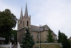
Ujazd, Opole Voivodeship
Ujazd Ujest | |
|---|---|
 Saint Andrew Church | |
| Country | |
| Voivodeship | Opole |
| County | Strzelce |
| Gmina | Ujazd |
| Area | |
| • Total | 14.69 km2 (5.67 sq mi) |
| Population (2006) | |
| • Total | 1,652 |
| • Density | 110/km2 (290/sq mi) |
| Postal code | 47-143 |
| Website | http://www.ujazd.pl |
Ujazd [ˈujast] (German: Ujest) is a town in Strzelce County in Opole Voivodeship of Poland. Population 1,647. 70% of the town infrastructure was destroyed in the Second World War.
The town lies on bank of the river Kłodnica.[1] Tourist attractions in the town include the Ujazd castle (formerly used by bishops of Wrocław) and two churches: 17th century baroque church, 19th century neogothic church.
Dukes of Ujest[2]
Ujazd (prior to 1945 part of Prussia) was original geographic location for the title the duke of Ujest, that was used by the head of the family of Hohenlohe–Öhringen, a branch (1823) of that of Hohenlohe-Ingelfingen. Prince Hugo of Hohenlohe-Öhringen was created first duke of Ujest in 1861, and in 1897 was succeeded by his son Christian Kraft (born 1848). The duke was an hereditary member of the upper houses of Württemberg and Prussia.[1]
References
- ^ a b Chisholm 1911, p. 564.
- ^ http://almanachdegotha.org/id318.html
- Attribution
- This article incorporates text from a publication now in the public domain: Chisholm, Hugh, ed. (1911). "Ujest". Encyclopædia Britannica. Vol. 27 (11th ed.). Cambridge University Press. p. 564.
External links
- http://www.ujazd.pl/
- http://bip.ujazd.pl/
- Jewish Community in Ujazd on Virtual Shtetl
50°24′N 18°21′E / 50.400°N 18.350°E


