
Unterreit
Unterreit | |
|---|---|
 Coat of arms | |
Location of Unterreit within Mühldorf am Inn district 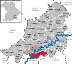 | |
 Unterreit  Unterreit | |
| Coordinates: 48°7′N 12°20′E / 48.117°N 12.333°E | |
| Country | Germany |
| State | Bavaria |
| Admin. region | Oberbayern |
| District | Mühldorf am Inn |
| Municipal assoc. | Gars am Inn |
| Government | |
| • Mayor | Gerhard Forstmeier |
| Area | |
| • Total | 32.20 km2 (12.43 sq mi) |
| Highest elevation | 560 m (1,840 ft) |
| Lowest elevation | 478 m (1,568 ft) |
| Population (2023-12-31)[1] | |
| • Total | 1,798 |
| • Density | 56/km2 (140/sq mi) |
| Time zone | UTC+01:00 (CET) |
| • Summer (DST) | UTC+02:00 (CEST) |
| Postal codes | 83567 |
| Dialling codes | 08073 |
| Vehicle registration | MÜ |
| Website | www.unterreit.de |
Unterreit is a municipality in the district of Mühldorf in Bavaria in Germany.
References
- ^ Genesis Online-Datenbank des Bayerischen Landesamtes für Statistik Tabelle 12411-003r Fortschreibung des Bevölkerungsstandes: Gemeinden, Stichtag (Einwohnerzahlen auf Grundlage des Zensus 2011).
| International | |
|---|---|
| National | |
This Mühldorf district location article is a stub. You can help Wikipedia by expanding it. |