Jump to content

Urakami

Coordinates: 32°46′26″N 129°51′48″E / 32.773753°N 129.863251°E / 32.773753; 129.863251
From Wikipedia, the free encyclopedia

This is an old revision of this page, as edited by Jllm06 (talk | contribs) at 03:51, 15 December 2011 (removed Category:Nagasaki Prefecture; added Category:Geography of Nagasaki Prefecture using HotCat). The present address (URL) is a permanent link to this revision, which may differ significantly from the current revision.

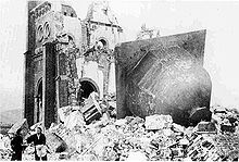
Urakami Tenshudo (Catholic Church in Nagasaki) destroyed by the atomic bomb, the bell of the church having toppled off.

Urakami was an area in the northern part of the city of Nagasaki. It is the exact ground zero where the atomic bomb exploded on August 9, 1945. It is the site of Urakami Cathedral, which was the largest cathedral in East Asia before it was destroyed by the bomb and then rebuilt.

32°46′26″N 129°51′48″E / 32.773753°N 129.863251°E / 32.773753; 129.863251 (ground zero)