User:Ierisera
| This user is a member of WikiProject Meteorology. |
Useful Links
[edit]
Quality Scales
[edit]Featured Aritcles These are the highest quality wikipedia articles that meet criteria and are peer-reviewed to ensure accuracy. These articles are generally thorough and in depth. What you would expect out of an encylcopedia. The articles are updated when relevant new material is published.
A-Class or quality articles These are well written, referenced, and quality articles. They don't necessarily have to be peer-reviewed but represent accurate information with verified references from a "hard" source.
Good article (B-class) Good articles contain a large majority information that would be good enough for a completed article but lack certain organizational qualities. Often it is an expansive list of information with some amount of editing recquired to make it a quality Article
Start These are articles that contain lots of meaningful inforamtion but lack completeness. The subject will can cover in depth some things but neglect other things. Lots of editing is recquired to bring these up to speed
Stub Stubs are either a short article or a rough collection ideas. They are usually very short and need lots of work to legitamize the article.
Mesoscale Project Proposal
[edit]Great Salt Lake Effect Snowstorms
The Great Salt Lake has a small but detectable effect on the local climate and weather. Lake-effect snowstorms are a common occurrence over the region and have major socio-economic impacts due to their significant precipitation amounts. The Great Salt lake never freezes and can warm rapidly which allows lake effect precipitation to occur from September through May. LAke enhanced snowstorms are often attrinbuterd to createing what is locally known as "THe Greatest SNow on Earth."
Lake Enhancement
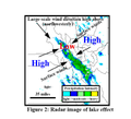
For the Great Salt Lake, lake effect snow is generated in a simialr fashion as elsewhere in the world. For the Great Salt Lake, ideal conditions for a lake effect snow occur when a strong, cold, northwesterly wind blows across a relatively warm lake. This is common after a cold front passage, where the winds are predominantly northwesterly and the air is much colder than the lake. When the land-lake breeze blows towards the lake there is a convergence zone that acts to channel the cold air over the center of the lake and further enhance precipitation. The salinity of the Great Salt Lake prevents freezing but reduces the saturation vapor pressure and latent heat flux into the overlying air. As a result minimal amounts of moisture and latent heat is added to the air moving over the lake. The Great Salt Lake primarily provides a lifting mechanism and acts as an atmospheric destabilizer, which encourages convection. This is in contrast to the Great Lakes where the lakes contribute significant amounts of moisture and latent heat. The high relief of the Wasatch mountains further capitalizes on lake enhancement and can receive multiple feat of snow from lake effect alone.
Forecasting Lake effect snow
Accurate prediction of snowstorms developing in the Lee of the great Salt Lake is one of the major forecast challenges facing northern Utah. Forecasting skill has dratically imporved in recent years due to a better observational network including the NEXRAD radar system. An accurate forecast involves indentifying the crucial requiremnents for lake effect precipitation. The basic requirements are a conditionally unstable environment, significant moisture and a lifting mechanism. Many different variables go into these requirements. Through extensive analyses and field experiments the understanding of lake effect snowstorms has improved drastically in recent years. Many general rules of thumb have been developed in order to predict the occurrence, location and severity of lake effect snow.
Rules of Thumb
- A strong Northwesterly flow maximizes precipitation for the Salt Lake Valley.
- A minimal temperature difference of 16°C between the surface and 700mb is needed but not necessarily sufficient in itself to cause lake effect snow.
- An inversion or stable layer below 700mb has never yielded lake effect snow.
- Lake effect snow can occur in concert with synoptic scale storm systems.
- A large lake-land temperature difference favors over-lake convergence.
- Lake effect is typically initiated during the night when land-breeze convergence is favored and convection occurs predominantly over the lake.
- During the daytime lake effect precipitation dissipates when solar heating creates scattered widespread convection over the land.
- The 700mb winds typically determine the geographic position of the precipitation
- Limited amounts of directional and vertical wind shear tend to produce heavier precipitation events.
- The Great Salt Lake contributes minimal amounts of moisture so that upstream moisture is a crucial variable.
Refernces:
Carpenter, D. M., 1993: The lake effect of the Great Salt Lake: Overview and forecast problems. Wea. Forecasting, 8, 181-193.
Steenburgh, W. J., S. F. Halvorson, and D. J. Onton, 2000: Climatology of lake-effect snowstorms of the Great Salt Lake. Mon. Wea. Rev. , 128, 709-727
Steenburgh, W. J, 1999: Lake Effect of the Great Salt Lake: Scientific Overview and Forecast Diagnostics. http://www.met.utah.edu/jimsteen/cirp/lake_diagnostics/


