User:WilliamWriter01/Lauterbach (Stolpen)
WilliamWriter01/Lauterbach | |
|---|---|
| Country | Germany |
| State | Saxony |
| Area | |
| • Total | 9.01 km2 (3.48 sq mi) |
| Elevation | 327 m (1,073 ft) |
| Population | |
| • Total | 581 |
| • Density | 64/km2 (170/sq mi) |
| Time zone | UTC+01:00 (CET) |
| • Summer (DST) | UTC+02:00 (CEST) |

Lauterbach is a district of Stolpen and is located Eastern of Dresden, 15 kilometres away from Bischofswerda. About 620 inhabitants live in Lauterbach.
The village is located at the border region between the Landkreis Bautzen and the Landkreis Sächsische Schweiz-Osterzgebirge . Since 1952 being part of the Kreis Bischofswerda, Lauterbach was a part of the Landkreis Sächsische Schweiz by 1994 which was absorbed into the Landkreis Sächsiche Schweiz-Osterzgebirge in 2008.
History
[edit]
| year | inhabitants |
|---|---|
| 1559 | 51 "besessene Mann", 31 housers, 26 housemates |
| 1764 | 51 "besessene Mann", 10 gardeners, 27 housers |
| 1834 | 594 |
| 1871 | 651 |
| 1890 | 743 |
| 1910 | 704 |
| 1925 | 749 |
| 1939 | 656 |
| 1946 | 880 |
| 1964 | 742 |
| 1990 | 626 |
| 2014 | 581 |
The Waldhufendorf was assigned to the Meißen Burgward Göda. In 1262, Lauterbach, in the documents recorded as Luterbach, came into the possessions of the Bishops of Meißen. Lauterbach belonged with episcopal office Stolpen to the electoral prince (german: Kurfürst) of Saxony in 1559. In the late 17th century, the local pastor created a branch of the significant family of scholars Stöckhardt. The place was assigned to the Governorship Pirna in 1875 and belonged to the newly formed Kreis Bischofswerda from 1952.
There were unsuccessful mining attempt near Lauterbach in the 17th century. In the Wesenitztal in 1622, a mine with the name "Invention of Christ, by Hans Winklers, above the Puschmühle" . It presumably was an attempt to obtain gold, which didn't end in success. It isn't passed down for how long the mine was in use. Ruins of the old spilled mine are still recognizable above the Buschmühle. This place is named "Goldhöhle" ("gold cave") colloquially.
Six streets lead to the place and connect to a main road through Lauterbach. The local hill of the village is the Gottlöbers Höhe or Gottlöber Berg as it is also called by the locals. With 381.6 metres of height, it counts as the higher elevations in the region.
Already in the GDR, the image of the place was characterized with agriculture.This didn't change until today. There are 10 bigger farm yards and two cow barns of the former Agricultural Production Cooperative (LPG). Many service firms are settled in Lauterbach, such as a smithy, an electrician and a beverage specialist market, that counts as one of the biggest in the region. The majority of the inhabitants works outside the village in the surrounding cities Stolpen, Neustadt or Bischofswerda.
Sights
[edit]St. Martin's church
[edit]

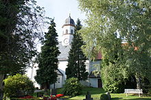
The cillage church consecrated to the saint Martin originated in 1495 as a catholic chapel and came under the chair of archpriest Jochgrim-Stolpen, with the introduction of the reformation it came to th Ephoria Bischofswerda. With the end of the archbishops' of Meißen leadership over Stolpen, the Lauterbach rectory came to the saxonian electoral princes, whose office in Stolpen also decided on the filling of the vicarage. Today, in addition to Lauterbach, the neighbouring villages Oberottendorf, Rückersdorf and Bühlau are also a part of the parish that counts about 1200 members in total.
The St. Martin's church consists of two parts, where the eastern one is the older and was built in the 12./13. century. It is a plain hall church with a closed chor. There was a bigger modification in 1870, where the church got today's roof turret. Inb 1981 and 1991, restoration work was done.
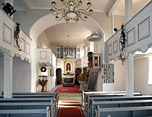
The furnishing is mainly from the 19th century. The church has a plain altar with two channeled columns with projecting entablature. A round arch nook serves as frame for the golden crucifix from wood. The underneath installed copper engraving plate shows a depiction of the last supper. At the south side of the chor is a plain wooden pulpit. A goblet-shaped baptismal font and a wrought iron processional cross from 1748 and a pipe organ built in 1932 in the workshop of the Jehmlichs complete the equipment.
Three bells are ringing in the tower that are consacrated to Mary Magdalene, Saint Anne and Virgin Mary. They were molded in 1513. Today, there are new bells.
Easter Column
[edit]
Almost outside Lauterbach, near the exit in direction of Bühlau, at the junction Dorfstraße / Niedere Straße there is the so-called "Easter column". It presumably originated as a prayer or tormenting column in pre-reformation times.
In 1584, it was redesigned by the Amtsschösser of Stolpen Thomas Treutzer in remembrance of an odd event in calender history. In 1582, pope Gregor XIII. introduced the Gregorian Calendar, which was obligatory for the Lausitz, Bohemia and Silesia from 1584. In the neighbouring electoral Saxony however, the old Julian Calendar was still in place. As a result, in the border region between Saxony and the Lausitz, Easter was celebrated two times within 10 days.
The Easter column is about 2.5 m (8'2'') and is inscripted with: 1584 JAR DAS IST WAR ZVENE OSTERN IN EINEN JAHR. (Year 1584 that's true two easters in one year) On the left side, there is an additional notice of the restoration in 1884. The square column is from sandstone and has a cube-shaped bit on top with a quartered roof. At the front, there is a depiction of Jesus Christ.
Literature
[edit]- Richard Steche: Lauterbach. In: Beschreibende Darstellung der älteren Bau- und Kunstdenkmäler des Königreichs Sachsen. 1. Heft: Amtshauptmannschaft Pirna. C. C. Meinhold, Dresden 1882, S. 44.
References
[edit]
- Der Bergbau zwischen Lauterbach und Stolpen – abgerufen am 17. März 2013
- Webseite der Kirchgemeinde Lauterbach-Oberottendorf – abgerufen am 17. März 2013
- Ulrich Eichler: Marter und Bildstock. Betsäulen in Sachsen, Verlag D.J.M., 2003, ISBN 978-3980309196
Links
[edit]- Daten der Stadt Stolpen
- Lauterbach im Digitalen Historischen Ortsverzeichnis von Sachsen
[[Category:Small village]] [[Category:German village]] [[Category:Beautiful village]] [[Category:Small church]] [[Category:Easter column]]
