User talk:Seekgeek/sandbox
Appearance
Red Hot Chili Peppers
[edit]| Header text | Header text | Header text | Header text |
|---|---|---|---|
| Example | Example | Example | Example |
| Example | Example | Example | Example |
| Example | Example | Example | Example |
| Example | Example | Example | Example |
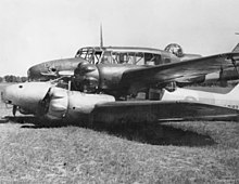
1940 Brocklesby mid-air collision
 The Avro Ansons after landing safely, having collided in mid-air and locked together, 29 September 1940 | |
| Accident | |
|---|---|
| Date | 29 September 1940 |
| Summary | Mid-air collision |
| Site | Brocklesby, New South Wales, Australia 36°48′S 146°41′E / 36.800°S 146.683°E |
| Total fatalities | 0 |
| Total injuries | 1 |
| Total survivors | 4 |
| First aircraft | |
| Type | Avro Anson |
| Operator | No. 2 Service Flying Training School RAAF |
| Registration | N4876 |
| Flight origin | RAAF Station Forest Hill, New South Wales |
| Destination | Corowa, New South Wales |
| Crew | 2 |
| Injuries | 0 |
| Survivors | 2 |
| Second aircraft | |
| Type | Avro Anson |
| Operator | No. 2 Service Flying Training School RAAF |
| Registration | L9162 |
| Flight origin | RAAF Station Forest Hill, New South Wales |
| Destination | Corowa, New South Wales |
| Crew | 2 |
| Injuries | 1 |
| Survivors | 2 |
