Vălenii de Munte
Appearance
Vălenii de Munte | |
|---|---|
Town | |
 The Nicolae Iorga memorial museum in Vălenii de Munte | |
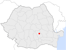
 Location of Vălenii de Munte | |
| Coordinates: 45°11′8″N 26°2′23″E / 45.18556°N 26.03972°E | |
| Country | |
| County | Prahova County |
| Status | Town |
| Government | |
| • Mayor | Florin Constantin (Social Democratic Party) |
| Area | |
| • Total | 21.59 km2 (8.34 sq mi) |
| Population (2002) | |
| • Total | 13,309 |
| Time zone | UTC+2 (EET) |
| • Summer (DST) | UTC+3 (EEST) |
| Website | http://www.valeniidemunte.com.ro/ |
Vălenii de Munte (Romanian pronunciation: [vəˈlenij de ˈmunte]) is a town in Prahova County, southern Romania (the historical region of Wallachia), with a population of about 13,309. It lies on the Teleajen River valley, 28 kilometres (17 mi) north of the county seat of Ploiești.
The town's sister cities are Eaubonne, Cimișlia, and Sarandë.
History
| Year | Pop. | ±% |
|---|---|---|
| 1912 | 3,704 | — |
| 1930 | 4,237 | +14.4% |
| 1948 | 4,491 | +6.0% |
| 1956 | 5,472 | +21.8% |
| 1966 | 7,380 | +34.9% |
| 1977 | 10,508 | +42.4% |
| 1992 | 13,689 | +30.3% |
| 2002 | 13,898 | +1.5% |
| 2011 | 11,707 | −15.8% |
| Source: Census data | ||
The first recorded reference about the town dates back to the 17th century.
Notable residents
- Gheorghe Pănculescu (1844-1924), engineer
- Nicolae Iorga (1871-1940), historian, politician, writer
- Nicolae Tonitza (1886-1940), painter
- Mădălina Manole (1967-2010), singer, actress
Museums
- Nicolae Iorga memorial house
- Teleajen Valley etnographic museum
- Plum tree growing natural science museum
- Queen Mary religious arts museum and national missionary school

Wikimedia Commons has media related to Vălenii de Munte.


