
Valley Chapel, West Virginia
Valley Chapel, West Virginia | |
|---|---|
| Country | United States |
| State | West Virginia |
| County | Lewis |
| Elevation | 1,017 ft (310 m) |
| Time zone | UTC-5 (Eastern (EST)) |
| • Summer (DST) | UTC-4 (EDT) |
| Area code(s) | 304 & 681 |
| GNIS feature ID | 1728692[1] |
Valley Chapel is an unincorporated community in Lewis County, West Virginia, United States. Valley Chapel is located along County Route 10, 5.15 miles (8.29 km) north-northwest of Weston.[2] Valley Chapel had a post office, which closed on January 24, 1998.[3]
The community was named after the nearby Valley Chapel church.[4]
References
- ^ "Valley Chapel". Geographic Names Information System. United States Geological Survey, United States Department of the Interior.
- ^ Lewis County, West Virginia General Highway Map (PDF) (Map). West Virginia Department of Transportation. 2011. p. 1. Retrieved March 6, 2012.
{{cite map}}: Cite has empty unknown parameter:|trans_title=(help) - ^ "Postmaster Finder - Post Offices by ZIP Code". United States Postal Service. Retrieved March 6, 2012.
- ^ Kenny, Hamill (1945). West Virginia Place Names: Their Origin and Meaning, Including the Nomenclature of the Streams and Mountains. Piedmont, WV: The Place Name Press. p. 643.
Municipalities and communities of Lewis County, West Virginia, United States | ||
|---|---|---|
| City | 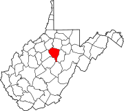 | |
| Town | ||
| Unincorporated communities |
| |
| Footnotes | ‡This populated place also has portions in an adjacent county or counties | |
This article about a location in Lewis County, West Virginia is a stub. You can help Wikipedia by expanding it. |