
Varadero
23°9′2″N 81°16′25.5″W / 23.15056°N 81.273750°W

Varadero is a popular resort town in the province of Matanzas, Cuba, and one of the largest resorts in the Caribbean.
Geography
It is situated on the Hicacos peninsula, some 140 kilometres east of Havana, at the eastern end of the Via Blanca highway. The peninsula is only 1.2 km wide at its widest point, and is separated from the island of Cuba by the Kawama Channel. This spit of land extends from the mainland in a northeasterly direction and its tip, Punta Hicacos, is the northernmost point of the island of Cuba. At the northeastern end of the peninsula there is a nature reserve with virgin forests and beaches.
Tourism
Varadero is first and foremost a tourist resort, and boasts more than 20 kilometres of white sandy beaches. Tourism grew as Irénée du Pont Nemours, an American millionaire, in the early 1930's built his estate on the peninsula. But the first tourists visited Varadero as early as the 1870's, and for years it was considered an elite resort. However, after the occurrence of the Cuban Revolution in 1959, the beach was opened to the people of Cuba and all the mansions were expropiated from their rich owners.
As of 2006, Varadero is primarily visited by European and Canadian tourists. The number of American tourists visiting Varadero, although increasing, has been limited because of the restrictions which prevent U.S. citizens from flying directly from the U.S. to Cuba. Juan Gualberto Gomez Airport (Varadero's airport) is the second-most important airport of the island after José Martí Airport in Havana.
Photo gallery
-
 Varadero Beach
 -
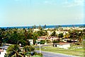 Town of Varadero
 -
 City Park in Varadero
 -
 Varadero Beach from the air


Varadero is also called Playa Azul.
External links
This Cuban location article is a stub. You can help Wikipedia by expanding it. |