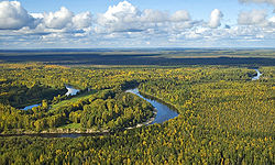
Vasyugan
Vasyugan (Russian: Васюга́н) is a river in the southern West Siberian Plain of Russia. It is a tributary of the Ob River on the left side, and its course from its source in the Vasyugan Swamp is entirely within the Kargasok district of Tomsk Oblast.
Statistics
The river is 1,082 kilometres (672 mi) long and is navigable upriver for 886 kilometres (551 mi) from the mouth. The Vasyugan drains a basin of 61,800 square kilometres (23,900 sq mi). Average annual runoff: 345 m³ / c, 10.9 km³ / year.

Tributaries:
- Right hand: Elizarovka, Petryakov, Half, Ershovka, Kalganak, Penorovka, Nyurolka, Winter, Chizhapka, Pasil, Silga, Naushki, Kochebilovka, Slogan.
- Left hand: Big Petryakov, Listvenka, cow, Starica, Gorchakov, kyn, burbot, deaf, Chertala, Yagylyah, Egolyah, Olenevka Kelvat, Lontynyah, Katylga, Tscheremschanka, pond, Makhno, Nutcracker, Martynovka, Varingegan, Ehomyah, Chebachya, Kacharma Minor Kuletka.
Municipalities (downstream from source): pp. New Vasyugan, d. Aypolovo, pp. New Tevriz, pp. Srednii Vasyugan, pp. Old Berezovka, pp. Ust-Chizhapka, pp. Naunak, pp. Most mane, pp. Staro Yugino, pp. Novo Yugino, pp. Bondarko.
Literature
- Evseeva NS Geography of Tomsk region. (Natural conditions and resources). - Tomsk: TSU, 2001, 223 pp.
59°05′35″N 80°42′25″E / 59.0931°N 80.7069°E
