
Velanai
Velanai
வேலணை වේලනෛයි | |
|---|---|
 | |
 Velanai | |
| Coordinates: 9°40′0″N 79°52′0″E / 9.66667°N 79.86667°E | |
| Country | Sri Lanka |
| Province | Northern |
| District | Jaffna |
Velanai (Tamil: வேலணை) is a small village in Velanai Island off the coast of Jaffna Peninsula in the North of Sri Lanka.[1][2]
The majority of the people are Hindus along with a minority of Christians. There are number of Hindu temples along with few churches. The village is also served by a dozen schools. Sir Vaithilingam Duraiswamy, a well known member of parliament during the British colonial period, and his son Yogendra Duraiswamy, a Hindu activist and well known diplomat, were born in Velanai.
Since 1983 Velanai has also been the scene of violence as part of the Sri Lankan civil war including the Allaipiddy massacre.[3][4]
Etymology
The name Velanai is believed to have been derived from the name of the Tamil god Velan (Tamil: வேலன்) (Murugan (Tamil: முருகன்)). Because god Murugan worship is so popular among all the peoples in Velanai.
History
Archaeological evidence
Received per-historic archaeological evidence of ancient life in Saatti (Tamil: சாட்டி) sea side[citation needed] suggested that there was a well-organized civilization emerged in this island.
Geography and climate
Velani is located at 9°24′N 79°32′E / 9.40°N 79.54°E. It is surrounded by the Palk Strait and at a distance of 6 kilometres (3.7 mi) south-west of Jaffna town. Though most of Velani district is a level plain and also has maximum elevation of 15 metres (49 ft) above mean sea level. The total area of this island is nearly 36 km2[citation needed].
Places of interest
- Vangalavadi Murugan Temple
- Saatti Sea side
Gallery
-
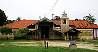 Velanai Vangalavadi Murugan Kovil

References
- ^ "AdministrativeMap" (PDF). United Nations Office for the Coordination of Humanitarian Affairs, Sri Lanka. United Nations Office for the Coordination of Humanitarian Affairs, Sri Lanka. 28 May 2007. Archived from the original (PDF) on 22 October 2007. Retrieved 13 August 2007.
{{cite news}}: Unknown parameter|dead-url=ignored (|url-status=suggested) (help) - ^ "District Secretariat Velanai". Gov of Sri Lanka. Gov of Sri Lanka.
- ^ K. T. Rajasingham (29 September 2001). "Sri Lanka: The Untold Story : Chapter 8: Pan Sinhalese board of ministers - A Sinhalese ploy". Asia Times Online. Retrieved 1 November 2009.
- ^ "Special Report No.2". University Teachers for Human Rights (Jaffna), Sri Lanka in association with Pax Christi (an international Catholic peacemaking movement). Retrieved 1 November 2009.
External links
9°40′N 79°52′E / 9.667°N 79.867°E
This Northern Province, Sri Lanka location article is a stub. You can help Wikipedia by expanding it. |