
Waddington Bay

Waddington Bay (65°16′S 64°5′W / 65.267°S 64.083°W) is a bay 2 nautical miles (3.7 km) long, in a NW-SE direction, and 1 nautical mile (1.9 km) wide, indenting the west coast of Kiev Peninsula, Graham Land, immediately north of Cape Tuxen. This bay is partially defined on the charts of the Belgian Antarctic Expedition, 1897–99, under Gerlache. It was more fully delineated by the French Antarctic Expedition, 1908–10, under Charcot, who named it for Senator Waddington, president of the Chamber of Commerce at Rouen.
A gentoo penguin colony was discovered at the southern headland of Waddington Bay in January 2014 by a group of kayakers. [1]
See also
References
-
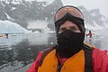
 Kayaker watches seal in Waddington Bay
 -
 Kayaker in Waddington Bay
 -
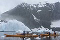 Kayakers in Waddington Bay
 -
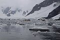 Kayaking in Waddington Bay
 -
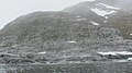 Gentoo penguin colony at southern headland of Waddington Bay


![]() This article incorporates public domain material from "Waddington Bay". Geographic Names Information System. United States Geological Survey.
This article incorporates public domain material from "Waddington Bay". Geographic Names Information System. United States Geological Survey.
This Graham Coast location article is a stub. You can help Wikipedia by expanding it. |