
Wadi Fara
| Wadi Fara | |
|---|---|
 | |
 | |
| Physical characteristics | |
| Mouth | |
• coordinates | 25°24′26.5″N 56°03′53.7″E / 25.407361°N 56.064917°E |
Wadi Fara is a seasonal watercourse, or wadi, in Ras Al Khaimah, United Arab Emirates. It runs from the confluence of the Wadi Asimah and Wadi Sidr, to the village of Ghayl.
A wide and fertile wadi, its rich wildlife includes a novel species of diving beetle, Hydroglyphus sinuspersicus, which was first discovered and documented by a joint Czech/Austrian team working in the Wadi Fara in 2009.[1]
The wadi is traditionally settled by members of the Mazari tribe and has a number of historic watchtowers, old villages and farms. A survey of the area carried out in 1955 found 25 households and some 1,200 date palms in the wadi.[2]
-
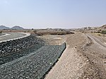 The Al Daoudi dam in the Wadi Fara
 -
 The confluence of the Wadi Fara with Wadi Asimah (right) and Wadi Sidr (left)
 -
 The Wadi Fara emerging at Ghayl, Ras Al Khaimah

_and_Wadi_Sidr_(Left).jpg)

See also[edit]
References[edit]
- ^ Hájek, Jirí; Wewalka, Günther (2009). "New and little known species of Hydroglyphus (Coleoptera: Dytiscidae) from Arabia and adjacent areas" (PDF). Acta Entomologica Musei Nationalis Pragae. 49 (1): 93–102.
- ^ Lancaster, William; Lancaster, Fidelity (2011). Honour is in Contentment: Life before oil in Ras al-Khaimah (UAE) and some neighbouring regions. Studien zur Geschichte und Kultur des islamischen Orients. Vol. 25. De Gruyter. p. 532. ISBN 978-3-11-022340-8. OCLC 763160662.