Wald (Allgäu)
Appearance
Wald | |
|---|---|
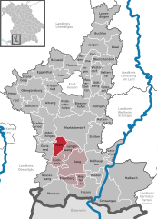
Location of Wald (Allgäu) within Ostallgäu district  | |
| Country | Germany |
| State | Bavaria |
| Admin. region | Schwaben |
| District | Ostallgäu |
| Government | |
| • Mayor | Josef Ampßler |
| Area | |
| • Total | 17.97 km2 (6.94 sq mi) |
| Elevation | 800 m (2,600 ft) |
| Population (2023-12-31)[1] | |
| • Total | 1,173 |
| • Density | 65/km2 (170/sq mi) |
| Time zone | UTC+01:00 (CET) |
| • Summer (DST) | UTC+02:00 (CEST) |
| Postal codes | 87616 |
| Dialling codes | 09463 |
| Vehicle registration | OAL |
| Website | www.wald-allgaeu.de |
Wald is a municipality in the district of Ostallgäu in Bavaria in Germany.
References
- ^ Genesis Online-Datenbank des Bayerischen Landesamtes für Statistik Tabelle 12411-003r Fortschreibung des Bevölkerungsstandes: Gemeinden, Stichtag (Einwohnerzahlen auf Grundlage des Zensus 2011).


