Warm front: Difference between revisions
→See also: Occluded front |
|||
| Line 62: | Line 62: | ||
[[Image:Warm front symbol.svg|thumb|right|200px|The warm front symbol: a line with semicircles pointing in the direction of the advancement of the front]] |
[[Image:Warm front symbol.svg|thumb|right|200px|The warm front symbol: a line with semicircles pointing in the direction of the advancement of the front]] |
||
you are correct hahahhaaaa |
|||
==See also== |
==See also== |
||
Revision as of 02:50, 28 October 2010

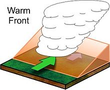
A warm front is defined as the leading edge of an advancing mass of warm air; it separates warm air from the colder air ahead.[1][2]
Development of warm fronts
Air masses are large bodies of air with similar properties of temperature and humidity that form over source regions, and the warm air masses behind warm fronts are not only warmer but higher in humidity than the colder air preceding them. Because of a warm air mass’s higher temperature and thus lesser density, mixing between the two air masses is unlikely. Being lighter, the warm air mass is unable to displace the cooler air mass and instead is forced upward along the upper boundary of the colder air in a process known as overrunning. The boundary between the two air masses has a gradual slope of 130 and lifting is slow but persistent.
As the air mass rises into regions of lower pressure, it expands and cools. As it cools, water vapor condenses and forms extensive cloud coverage. The first clouds to form along the sloping surface of the cold air are high cirrus, which thicken to cirrostratus and altostratus. Once the clouds have thickened to 2500 m from the earth’s surface, rain can begin to fall from the heavy nimbostratus cloud.
If the air mass is relatively stable, rainfall will increase until the front reaches the location, at which time the clouds can extend all the way to the earth’s surface as fog. Once the front passes, the location experiences quick warming and clearing. If the air mass is unstable, thunderstorms may precede and follow the front.
In the northern hemisphere, a warm front causes a shift of wind from southeast to southwest, and in the southern hemisphere a shift from northeast to northwest. Common characteristics associated with warm fronts include:
| Weather phenomenon | Prior to the Passing of the Front | While the Front is Passing | After the Passing of the Front |
|---|---|---|---|
| Temperature | Cool | Warming suddenly | Warmer, then leveling off |
| Atmospheric pressure | Decreasing steadily | Leveling off | Slight rise followed by a decrease |
| Winds |
|
Variable |
|
| Precipitation | Showers, snow, sleet, or drizzle | Light drizzle | Usually none, sometimes light rain or showers |
| Clouds | cirrus, cirrostratus, altostratus, nimbostratus, then stratus (pilots use the acronym CCANS) and fog; occasionally cumulonimbus in summer | Stratus, sometimes cumulonimbus | Clearing with scattered stratus, sometimes scattered cumulonimbus |
| Visibility | Poor | Poor, but improving | Fair in haze |
| Dew Point | Steady rise | Steady | Rise, then steady |
On weather maps, the surface location of a warm front is marked with a red line of half circles pointing in the direction of the front. On colored weather maps, warm fronts are illustrated with a solid red line.

you are correct hahahhaaaa
